 Outline Views, Hawes and Wastwater

|

|
|
|
item:- JandMN (37_21) image:- © see bottom of page |
click to enlarge |
|
|
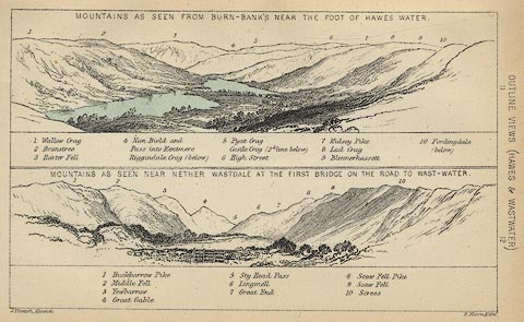
Print, lithograph, Outline Views, Haws and Wastwater -
Mountains as seen from Burn-Banks near the Foot of Hawes
Water, and Mountains as seen near Nether Wastdale at the
First Bridge on the road to Wast-Water, by J Flintoft,
Keswick, Cumberland, engraved by R Mason, Edinburgh,
Lothian, about 1900.
Tipped in opposite p.200 of Black's Guide to the English Lakes, editor A R Hope Moncrieff, published by Adam and Charles Black, London, 23rd edn 1900. Each scene has a list of mountains keyed by number to the drawing. The Haweswater view includes Haweswater and mountains behind from Wallow Carg, Branstree and Harter Fell to Blennerhassett. The Wastdale view includes mountians from Buckbarrow Pike across Great Gable to The Screes. |
||
| source type:- | Black 1856 (23rd edn 1900) | |
| inscription:- |
printed bottom, left and right
J. Flintoft, Keswick / R. Mason, Edinr. |
|
| inscription:- |
printed above upper image
MOUNTAINS AS SEEN FROM BURN-BANKS NEAR THE FOOT OF HAWES WATER. |
|
| inscription:- |
printed key to upper image
1 Wallow Crag / 2 Branstree / 3 Harter Fell / 4 Nan Bield and Pass into Kentmere / Riggindale Crag (below) / 5 Pyat Crag / Castle Crag (2nd line below) / 6 High Street / 7 Kidsey Pike / 8 Lad Crag / 9 Blennerhasset / 10 Fordingdale (below) hill names |
|
| inscription:- |
printed above lower image
MOUNTAINS AS SEEN NEAR NETHER WASDALE AT THE FIRST BRIDGE ON THE ROAD TO WAST-WATER. |
|
| inscription:- |
printed key to lower image
1 Buckbarrow Pike / 2 Middle Fell / 3 Yewbarrow / 4 Great Gable / 5 Sty Head Pass / 6 Lingmell / 7 Great End / 8 Scaw Fell Pike / 9 Scaw Fell / 10 Screes hill names |
|
| wxh:- | 14.5x9cm | |