 Mawson 1890s

|

|
|
|
item:- JandMN (50_271) image:- © see bottom of page |
click to enlarge |
|
|
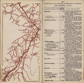
Strip map, road map, part of Newcastle to Keswick,
Patterdale, Penrith, and Carlisle, scale roughly 2 miles to
1 inch, published by Mawson, Swan, and Morgan, Newcastle
upon Tyne, Tyne and Wear, late 1890s.
Published in the road book, Itinerary of the Great North Road, by Mawson, Swan, and Morgan, late 1890s. From Ullswater through Pooley Bridge, Westmorland; then Penrith to near Salkeld, Cumberland. |
||

|
Mawson 1890s | |
| map feature:- | up is N & rivers & lakes & settlements & roads & railways | |
| inscription:- |
printed title, top
NEWCASTLE TO KESWICK, PATTERDALE, PENRITH, AND CARLISLE - continued. |
|
| wxh, map:- | 171x81mm | |
| scale:- | 1 to 130000 ? (rough estimate) | |