 Mawson 1890s

|

|
|
|
item:- JandMN (50_197) image:- © see bottom of page |
click to enlarge |
|
|
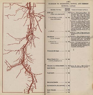
Strip map, road map, part of Durham to Richmond, Hawes,
and Kirkby Kendal, scale roughly 2 miles to 1 inch,
published by Mawson, Swan, and Morgan, Newcastle upon Tyne,
Tyne and Wear, late 1890s.
Published in the road book, Itinerary of the Great North Road, by Mawson, Swan, and Morgan, late 1890s. From Askrigg, past the Moorcock Inn, to about Garsdale, Yorkshire. |
||

|
Mawson 1890s | |
| map feature:- | up is E & rivers & lakes & settlements & roads & railways | |
| inscription:- |
printed title, top
DURHAM TO RICHMOND, HAWES, AND KIRKBY KENDAL - continued. |
|
| wxh, map:- | 171x81mm | |
| scale:- | 1 to 130000 ? (rough estimate) | |