 Marr 1909-12

|

|
|
|
item:- JandMN (75_3) image:- © see bottom of page |
click to enlarge |
|
|
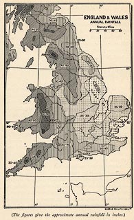
Map, England and Wales Annual Rainfall, scale about 100
miles to 1 inch, by George Philip and Son, The London
Geographical Institute, Published by Cambridge University
Press, Cambridge, Cambridgeshire, 1909.
On p.72 of Westmorland in the Cambridge County Geographies Series, by J E Marr. |
||

|
Marr 1909-12 (EW) | |
| map feature:- | up is N & scale line & lat and long scales & sea areas & coast line & rainfall | |
| inscription:- |
printed upper right
ENGLAND & WALES / ANNUAL RAINFALL |
|
| inscription:- |
printed bottom right
GEORGE PHILIP & SON LTD. |
|
| scale line:- | 80 miles = 20.5 mm | |
| wxh, map:- | 88x140mm | |
| scale:- | 1 to 6300000 ? (1 to 6280367 from scale line) | |