 Otley 1818

|

|
|
|
item:- Armitt Library : A1178.1 image:- © see bottom of page |
click to enlarge |
|
|
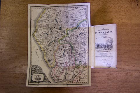
Map, hand coloured engraving, The District of the Lakes,
Cumberland, Westmorland, and Lancashire, scale about 4 miles
to 1 inch, by Jonathan Otley, 1818, engraved by J Menzies
and Son, Edinburgh, Scotland, 1841, published by Jonathan
Otley, Keswick, Cumberland, 1842.
Included in A Descriptive Guide of the English Lakes, by Jonathan Otley, 7th edition, 1842. There is a table of symbols for the map in the guide book. |
||

|
Otley 1818 | |
| map feature:- | mounted (on linen) & folded (top down, bottom up, zigzag in) & plain cartouche & north point & magnetic deviation (26d W) & scale line & lat and long scales & sea plain & coast shaded & rivers & lakes & relief & hill hachuring & table of heights & settlements & roads & canals & table of symbols (in guide book) | |
| inscription:- |
printed title cartouche, lower left
THE DISTRICT / OF THE / LAKES / By J. OTLEY. |
|
| inscription:- |
printed bottom left and right
KESWICK Published by Jona. Otley 2d. Augt. 1841. / Engd. by J. Menzies & Son EDINR. |
|
| scale line:- | 10 miles = 61.1 mm | |
| wxh, sheet:- | 27x36cm | |
| wxh, map:- | 255x342mm | |
| scale:- | 1 to 260000 ? (1 to 263395 from scale line) | |
|
|
notes | |