 Otley 1818

|

|
|
|
item:- Armitt Library : A1174.1 image:- © see bottom of page |
click to enlarge |
|
|
Map, engraving, The District of the Lakes, Cumberland,
Westmorland, and Lancashire, scale about 4 miles to 1 inch,
by Jonathan Otley, 1818, engraved by J and G Menzies and
Son, Edinburgh, Scotland, published by Jonathan Otley,
Keswick, Cumberland, 1827.
Tipped in before the half title page of A Concise Description of the English Lakes, by Jonathan Otley, 3rd edition 1827. |
||

|
Otley 1818 | |
| map feature:- | folded (zigzag up, zigzag in) & plain cartouche & north point & magnetic deviation (26d W) & scale line & lat and long scales & sea plain & coast shaded & rivers & lakes & relief & hill hachuring & table of heights & settlements & roads & canals | |
| inscription:- |
printed title cartouche, lower left
The District / of the / LAKES; / By J. Otley. |
|
| inscription:- |
printed Bottom left and right
KESWICK Published by Jona. Otley 21st. June 1827. / Engraved by J. & G. Menzies, Edinr. |
|
| inscription:- |
printed back cover of guide book
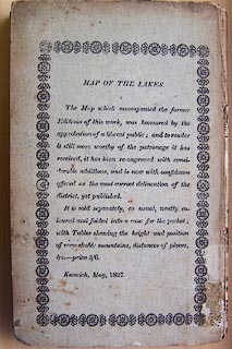
MAP OF THE LAKES. / The Map which accompanied the former Editions of this work, was honoured by the approbation of a liberal public; and to render it still more worthy of the patronage it has received, it has been re-engraved with considerable additions, and is now with confidence offered as the most correct delineation of the district, yet published. / It is sold separately, as usual, neatly coloured and folded into a case for the pocket; with Tables shewing the height and position of remarkable mountains, distances of places, &c.- price 3/6. / Keswick, May, 1827. |
|
| scale line:- | 10 miles = 63.1 mm | |
| wxh, folded:- | 10.5x17.5cm | |
| wxh, sheet:- | 28x38cm | |
| wxh, plate:- | 279x354mm | |
| wxh, map:- | 260x337mm | |
| scale:- | 1 to 260000 ? (1 to 255047 from scale line) | |