 Otley 1818

|

|
|
|
item:- Armitt Library : A1171.1 image:- © see bottom of page |
click to enlarge |
|
|
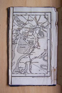
Map, uncoloured engraving, The District of the Lakes,
Cumberland, Westmorland, and Lancashire, scale about 4 miles
to 1 inch, by Jonathan Otley, 1818, engraved by J and G
Menzies and Son, Edinburgh, Scotland, published by Jonathan
Otley, Keswick, Cumberland, 1825.
Tipped in as frontispiece to A Concise Description of the English Lakes, by Jonathan Otley, 2nd edition 1825. |
||

|
Otley 1818 | |
| map feature:- | folded & plain cartouche & north point & magnetic deviation (26d W) & scale line & lat and long scales & sea plain & coast shaded & rivers & lakes & relief & hill hachuring & table of heights & settlements & roads & canals | |
| inscription:- |
printed title cartouche, lower left
The District / of the / LAKES / By J. Otley / KESWICK 1818. |
|
| inscription:- |
printed bottom left and right
2d. Edit. 1825. / Engraved by J. & G. Menzies, Edinr. |
|
| scale line:- | 10 miles = 61.9 mm | |
| wxh, folded:- | 10.5x17cm | |
| wxh, sheet:- | 28x35cm | |
| wxh, map:- | 257x316mm | |
| scale:- | 1 to 260000 ? (1 to 259991 from scale line) | |
|
|
notes | |