 Otley 1818

|

|
|
|
item:- Armitt Library : A1828 image:- © see bottom of page |
click to enlarge |
|
|
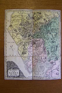
Map, hand coloured engraving, The District of the Lakes,
Cumberland, Westmorland, and Lancashire, scale about 4 miles
to 1 inch, by Jonathan Otley, engraved by J and G Menzies,
Edinburgh, Scotland, published by Jonathan Otley, Keswick,
Cumberland, 1818.
Sectioned for folding, mounted, and folded in a slip case. |
||

|
Otley 1818 | |
| map feature:- | sectioned for folding (2x3) & mounted (linen) & folded & slip case (leather) & plain cartouche & north point & magnetic deviation (26d W) & scale line & lat and long scales & sea plain & coast shaded & rivers & lakes & relief & hill hachuring & table of heights & county & settlements & roads & canals | |
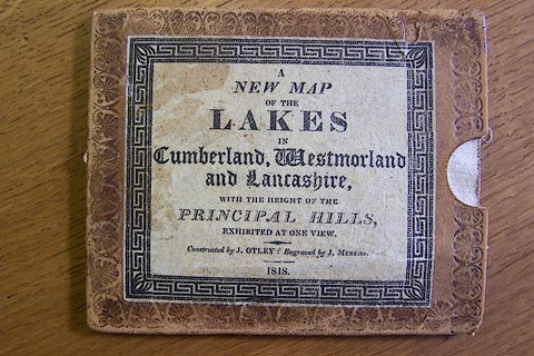
| inscription:- |
printed paper label on slip case
A / NEW MAP / OF THE / LAKES / IN / Cumberland, Westmorland / and Lancashire, / WITH THE HEIGHTS OF THE / PRINCIPAL HILLS, / EXHIBITED AT ONE VIEW. / Constructed by J. OTLEY : Engraved by J. MENZIES. / 1818. |
|
| inscription:- |
printed title cartouche, lower left
The District / of the / LAKES / By J. Otley / KESWICK 1818. |
|
| inscription:- |
printed bottom right
Engraved by J. & G. Menzies, Edinr. |
|
| scale line:- | 10 miles = 61.5 mm | |
| scale:- | 1 to 260000 ? (1 to 261682 from scale line) | |
| wxh, folded:- | 13.5x11cm | |
| wxh, slip case:- | 14x11.5cm | |
| wxh, sheet:- | 26.5x32.5cm | |
| wxh, map (including gaps):- | 259x319mm | |
|
||
|
|
notes | |
|
|
notes | |