 Otley 1818

|

|
|
|
item:- private collection (32) image:- © see bottom of page |
click to enlarge |
|
|
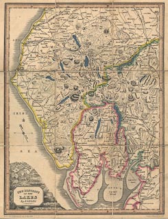
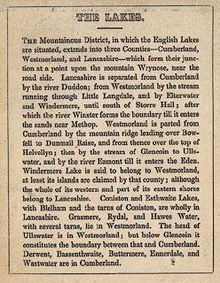
Map, hand coloured engraving, The District of the Lakes,
Cumberland, Westmorland, and Lancashire, scale about 4 miles
to 1 inch, by Jonathan Otley, 1818, engraved by J and G
Menzies, Edinburgh, Scotland, published by Jonathan Otley,
Keswick, Cumberland, 1849.
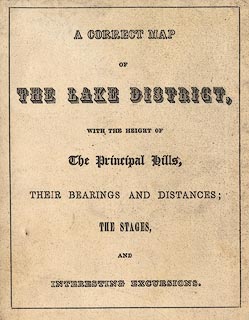
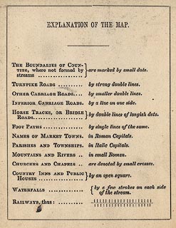
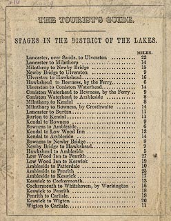
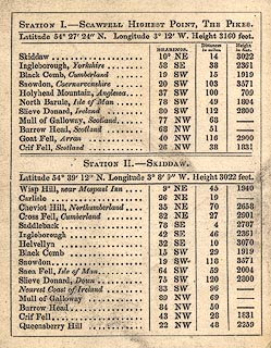
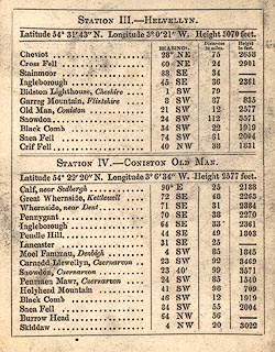
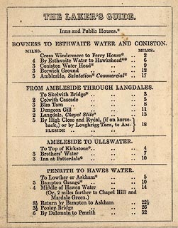
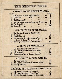
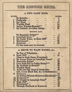
This late edition shows railways - parts of the Lancaster and Carlisle Railway, Kendal and Windermere Railway, Furness Railway, Cockermouth and Workington Railway, part of the Maryport and Carlisle Railway, and Whitehaven Junction Railway. Sectioned for folding, mounted, and folded with a card cover. The reverse of the map has introductory text, title page, table of symbols, introduction, table of distances of journeys, descriptions of views from four stations, on Scawfell, Skiddaw, Helvellyn, and Coniston Old Man, and itineraries. |
||

|
Otley 1818 | |
| map feature:- | sectioned for folding (3x3) & mounted & folded & card cover & plain cartouche & north point & magnetic deviation & scale line & lat and long scales & sea plain & coast shaded & rivers & lakes & relief & hill hachuring & table of heights & county & settlements & roads & canals & railways | |
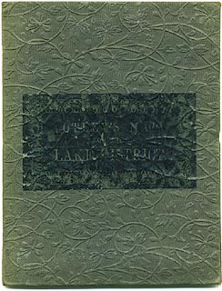
| inscription:- |
printed label on card cover
OTLEY'S MAP / OF THE / LAKE DISTRICT |
|
| inscription:- |
printed title cartouche, lower left
THE DISTRICT / OF THE / LAKES / By J. OTLEY. |
|
| inscription:- |
printed bottom
KESWICK Published by Jona. Otley 2d. May 1849. / Engd by J. Menzies & Son, EDINR. |
|
| inscription:- |
printed title page on reverse of map
A CORRECT MAP / OF / THE LAKE DISTRICT / WITH THE HEIGHTS OF / The Principal Hills, / THEIR BEARINGS AND DISTANCES; / THE STAGES, / AND / INTERESTING EXCURSIONS. |
|
| scale:- | 1 to 250000 ? | |
| wxh, folded:- | 9.5x12cm | |
| wxh, cover:- | 10.5x13.5cm | |
| wxh, sheet:- | 28x35.5cm | |
| wxh, map (including gaps):- | 260x343mm | |
|
||
|
||
|
||
|
||
|
||
|
||
|
||
|
||
|
||
|
||