 View of Ambleside

|

|
|
|
item:- Dove Cottage : Lowther.14 image:- © see bottom of page |
click to enlarge |
|
|
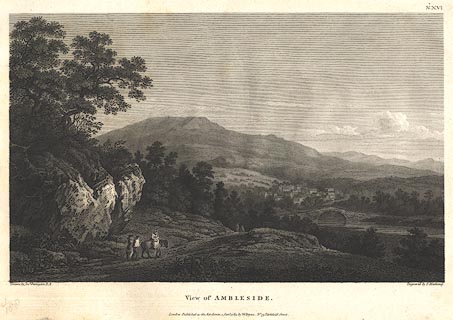
Print, engraving, View of Ambleside, Lakes, Westmorland,
painted by Joseph Farington, engraved by T Medland,
published by W Byrne, 69 Titchfield Street, London, 1789.
Presumably Rothay Bridge in the foreground, Scandale fell in the background? Plate 16 from Views of the Lakes, &c, in Cumberland and Westmorland, published 1789. Pasted in the Lowther scrapbook, vol.1; between pp.190-191; with descriptive text:- VIEW of AMBLESIDE. / AMBLESIDE is situated on the swift Decline of a Hill, over which many high Mountains rise towards the North. In Camden's Time, various ruins of the antient Amboglana of the Romans were to be seen here. Near the Head of Windermere, and at a little Distance from the Point where this View was taken, is the vestige of a Roman Station. It lies in a Meadow on a Level with the Lake, and, as supposed, was called the Dictis, where a Part of the Cohort of the Numerous Dictentium was stationed. The Extent of the Fortress, as he gives Dimensions, was one hundred and thirty-two Ells in Length and eighty in Breadth. Its Form an oblong Square with obtuse Angles. It is placed near the Meeting of all the Roads from Penrith, Keswick, Ravenglass, Furness and Kendal, which it commanded, and was accessible only on one Side. Roman Bricks, Urns, and other earthen Vessels, Coins, Mill-Stones or Quern-Stones, as he calls them, were frequently found here. The natural Beauties of this Part of the Country are of a very superior Order. It would scarcely be partial to say that a greater Variety of romantic and picturesque Scenery is to be found in the Neighbourhood of Ambleside, than can be met with in any other Part of this interesting Country within the same Compass. |
||
| source type:- | Farington 1789 (plate 16) | |
| inscription:- |
printed top right
No.XVI |
|
| inscription:- |
printed bottom, left, right and centre
Drawn by Josh. Farington, R.A. / Engraved by T. Medland. / View of AMBLESIDE. / London : Published as the Act directs, 1 Jany. 1789, by W. Byrne, No.79, Titchfield Street. |
|
| wxh, sheet:- | 48.5x30.5cm | |
| wxh, plate:- | 365x253mm | |
| wxh, print:- | 335x208mm | |
|
from:- Scrapbook, 4 volumes, History of Westmorland and Cumberland Illustrated, of descriptive texts, maps, and prints of views and coats of arms, for Westmorland and Cumberland, assembled by a member of the Lowther Family, late 18th early 19th century. The volumes are quarter bound, with marbled paper on the covers; each has a bookplate inside the front cover. The pages cut from various sources are nicely mounted, two sided pieces set neatly in a window in the scrapbook page. The main content is the whole of the two volumes of The History and Antiquities of the Counties of Westmorland and Cumberland, by Joseph Nicolson and Richard Burn, published London, 1777. Nicolson and Burn volume 1 is in scrapbook volumes 1 and 2, volume 2 in scrapbook volumes 3 and 4. Maps and prints are interspersed to make an illustrated version of the history. Some of the sources of maps and prints have been recognised:- Maps - coast of Cumberland etc by Andrew Dury, 1764; Westmorland and Cumberland by Richard Blome, 1673; sheets from Britannia Depicta, Emanuel Bowen, 1720; Cumberland by John Speed, Henry Overton edn 1695; Cumberland by John Cary 1787. Prints from the Set of prints, 20 engravings, Views of the Lakes etc in Cumberland and Westmorland, drawn by Joseph Farington, published by William Byrne, London, 1789. Note that plate numbers vary from edition to edition of this set. Prints from the Antiquities of Great Britain, drawings by Thomas Hearne, engraved by William Byrne, published by Hearne and Byrne, London, 1786-1807. Prints from Britannia Illustrata, drawings by Leonard Knyff, engraved by John Kip, published London, 1707-1740. Print from A Tour in England and Scotland, by Thomas Newte, published by G G J and J Robinson, Paternoster Row, London, 1788.. Some of the coat of arms are cut from A Display of Heraldrie by John Guillim late Pursuivant at Armes, published London, about 1610-11 to 1755. Coats of arms probably from The Baronetage of England, by Edward Kimber and Richard Johnson, published London? 1771. Pages from The Antiquarian Repertory, by Francis Grose, Thomas Astle, et al, published London, 1775-1809. Text from the Baronetage of England by Collins? Scraps cut from an unidentified gazetteer. At the end is the title page and pp.7-51 from A General View of the Agriculture of the County of Cumberland, by John Bailey and George Culley, published by C Macrae, London, 1794. Individual maps and prints are documented separately; with a note of their position in the scrapbooks. inscription:- : embossed: label on spine: (tatty remains): HI[ ] / [ ]/WEST[ ]M[ ] / [ ] / CUM[ ]M[ ] / ILLUS[ ]T[E ] inscription:- : printed & embossed: bookplate: gold on grey; crest, 6 annulets from the coat of arms, flowers, thistles: LOWTHER |
||