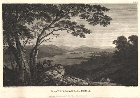
 View of Windermere from Gill Head

|

|
|
|
item:- Dove Cottage : Lowther.11 image:- © see bottom of page |
click to enlarge |
|
|
Print, engraving, View of Windermere from Gill Head,
Westmorland, painted by Joseph Farington, engraved by T
Medland, published by W Byrne, 69 Titchfield Street, London,
1788.
View down the lake, Belle Isle clear in the distance. Plate 14 from Views of the Lakes, &c, in Cumberland and Westmorland, published 1789. Pasted in the Lowther scrapbook, vol.1; between pp.184-185; with descriptive text:- VIEW of WINDERMERE from GILL-HEAD. / WINDERMERE or WINANDERMERE as it is sometimes called, is the largest of the Lakes, extending from North to South upwards of ten Miles. In Breadth it rarely exceeds one, and narrows considerably towards the lower End. The Northern and Western Coasts are wild and mountainous, the Eastern and Southern are more depressed, being in some Parts cultivated, in others woody. At about an equal Distance from each Extremity stands the Village of Bowness. Opposite to it the Lake is divided into two Parts by a Cluster of Islands, one of which, being much larger than the rest is usually called the Great-Island. The Drawing of this Subject was made near a Place called Gill-Head, about three Miles below Bowness. It comprehends a general View of the Lake looking towards the North. The Accompanyments of this Lake are highly beautiful, and its Extent gives it an Air of great Magnificence. |
||
| source type:- | Farington 1789 (plate 14) | |
| inscription:- |
printed top right
No.XIV |
|
| inscription:- |
printed bottom, left, right and centre
Drawn by Josh. Farington, R.A. / Engraved by T. Medland. / View of WINDERMERE, from Gill-Head. / Published as the Act directs, 15 Jany. 1788, by W. Byrne, No.79, Titchfield Street, London. |
|
| wxh, sheet:- | 49x30cm | |
| wxh, plate:- | 366x251mm | |
| wxh, print:- | 341x209mm | |
|
from:- Scrapbook, 4 volumes, History of Westmorland and Cumberland Illustrated, of descriptive texts, maps, and prints of views and coats of arms, for Westmorland and Cumberland, assembled by a member of the Lowther Family, late 18th early 19th century. The volumes are quarter bound, with marbled paper on the covers; each has a bookplate inside the front cover. The pages cut from various sources are nicely mounted, two sided pieces set neatly in a window in the scrapbook page. The main content is the whole of the two volumes of The History and Antiquities of the Counties of Westmorland and Cumberland, by Joseph Nicolson and Richard Burn, published London, 1777. Nicolson and Burn volume 1 is in scrapbook volumes 1 and 2, volume 2 in scrapbook volumes 3 and 4. Maps and prints are interspersed to make an illustrated version of the history. Some of the sources of maps and prints have been recognised:- Maps - coast of Cumberland etc by Andrew Dury, 1764; Westmorland and Cumberland by Richard Blome, 1673; sheets from Britannia Depicta, Emanuel Bowen, 1720; Cumberland by John Speed, Henry Overton edn 1695; Cumberland by John Cary 1787. Prints from the Set of prints, 20 engravings, Views of the Lakes etc in Cumberland and Westmorland, drawn by Joseph Farington, published by William Byrne, London, 1789. Note that plate numbers vary from edition to edition of this set. Prints from the Antiquities of Great Britain, drawings by Thomas Hearne, engraved by William Byrne, published by Hearne and Byrne, London, 1786-1807. Prints from Britannia Illustrata, drawings by Leonard Knyff, engraved by John Kip, published London, 1707-1740. Print from A Tour in England and Scotland, by Thomas Newte, published by G G J and J Robinson, Paternoster Row, London, 1788.. Some of the coat of arms are cut from A Display of Heraldrie by John Guillim late Pursuivant at Armes, published London, about 1610-11 to 1755. Coats of arms probably from The Baronetage of England, by Edward Kimber and Richard Johnson, published London? 1771. Pages from The Antiquarian Repertory, by Francis Grose, Thomas Astle, et al, published London, 1775-1809. Text from the Baronetage of England by Collins? Scraps cut from an unidentified gazetteer. At the end is the title page and pp.7-51 from A General View of the Agriculture of the County of Cumberland, by John Bailey and George Culley, published by C Macrae, London, 1794. Individual maps and prints are documented separately; with a note of their position in the scrapbooks. inscription:- : embossed: label on spine: (tatty remains): HI[ ] / [ ]/WEST[ ]M[ ] / [ ] / CUM[ ]M[ ] / ILLUS[ ]T[E ] inscription:- : printed & embossed: bookplate: gold on grey; crest, 6 annulets from the coat of arms, flowers, thistles: LOWTHER |
||