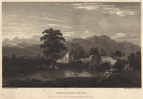
 North Entrance to Keswick

|

|
|
|
item:- Dove Cottage : Lowther.52 image:- © see bottom of page |
click to enlarge |
|
|
Print, engraving, North Entrance to Keswick, painted by
Joseph Farington, engraved by W Byrne and T Medland,
published by W Byrne, 79 Titchfield Street, London, 1787.
Greta Bridge and the River Greta. Plate 9 from Views of the Lakes, &c, in Cumberland and Westmorland, published 1789. Pasted in the Lowther scrapbook, vol.3; between pp.84-85; with descriptive text:- VIEW OF KESWICK. / KESWICK stands on the north of Derwentwater, and at no great distance from it. It is a small market-town chiefly deriving it's importance from it's situation, being usually made the head-quarters of the inquisitive traveller. The point of view is at the entrance on the road from Cockermouth. The bridge in the foreground is over the Greata, which joins the Derwent a little below in it's course from Derwent to Bassenthwaite-water. Behind the houses on the right stands castlett-crag at the foot of which runs the road to Lodore. The rocks which serve as a back ground to the scene are Wallow-crag, Eve-crag, &c. hanging over the eastern side of the lake. Keswick is eighteen miles distant from Winandermere, and fourteen from Ullswater. It ought to be observed here, as it was done before with respect to the timber and coppice-woods, that the bridges in this country are liable to perpetual alterations on account of the violence of the torrents; it is not therefore to be wondered at if the representation given of them should sometimes vary from the present form. |
||
| source type:- | Farington 1789 (plate 9) | |
| inscription:- |
printed bottom, left, right, centre
Drawn by Josh. Farington R.A. / Engraved by W. Byrne & T. Medland. / NORTH ENTRANCE to KESWICK. / Published as the Act directs, 2d. April 1787, by Wm. Byrne, No.79 Titchfield Street, London. |
|
| wxh:- | 34.5x24.5cm | |
|
from:- Scrapbook, 4 volumes, History of Westmorland and Cumberland Illustrated, of descriptive texts, maps, and prints of views and coats of arms, for Westmorland and Cumberland, assembled by a member of the Lowther Family, late 18th early 19th century. The volumes are quarter bound, with marbled paper on the covers; each has a bookplate inside the front cover. The pages cut from various sources are nicely mounted, two sided pieces set neatly in a window in the scrapbook page. The main content is the whole of the two volumes of The History and Antiquities of the Counties of Westmorland and Cumberland, by Joseph Nicolson and Richard Burn, published London, 1777. Nicolson and Burn volume 1 is in scrapbook volumes 1 and 2, volume 2 in scrapbook volumes 3 and 4. Maps and prints are interspersed to make an illustrated version of the history. Some of the sources of maps and prints have been recognised:- Maps - coast of Cumberland etc by Andrew Dury, 1764; Westmorland and Cumberland by Richard Blome, 1673; sheets from Britannia Depicta, Emanuel Bowen, 1720; Cumberland by John Speed, Henry Overton edn 1695; Cumberland by John Cary 1787. Prints from the Set of prints, 20 engravings, Views of the Lakes etc in Cumberland and Westmorland, drawn by Joseph Farington, published by William Byrne, London, 1789. Note that plate numbers vary from edition to edition of this set. Prints from the Antiquities of Great Britain, drawings by Thomas Hearne, engraved by William Byrne, published by Hearne and Byrne, London, 1786-1807. Prints from Britannia Illustrata, drawings by Leonard Knyff, engraved by John Kip, published London, 1707-1740. Print from A Tour in England and Scotland, by Thomas Newte, published by G G J and J Robinson, Paternoster Row, London, 1788.. Some of the coat of arms are cut from A Display of Heraldrie by John Guillim late Pursuivant at Armes, published London, about 1610-11 to 1755. Coats of arms probably from The Baronetage of England, by Edward Kimber and Richard Johnson, published London? 1771. Pages from The Antiquarian Repertory, by Francis Grose, Thomas Astle, et al, published London, 1775-1809. Text from the Baronetage of England by Collins? Scraps cut from an unidentified gazetteer. At the end is the title page and pp.7-51 from A General View of the Agriculture of the County of Cumberland, by John Bailey and George Culley, published by C Macrae, London, 1794. Individual maps and prints are documented separately; with a note of their position in the scrapbooks. inscription:- : embossed: label on spine: (tatty remains): HI[ ] / [ ]/WEST[ ]M[ ] / [ ] / CUM[ ]M[ ] / ILLUS[ ]T[E ] inscription:- : printed & embossed: bookplate: gold on grey; crest, 6 annulets from the coat of arms, flowers, thistles: LOWTHER |
||