 Grange in Borrowdale

|

|
|
|
item:- Dove Cottage : Lowther.54 image:- © see bottom of page |
click to enlarge |
|
|
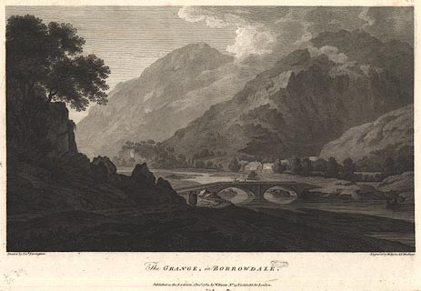
Print, engraving, The Grange in Borrowdale, painted by
Joseph Farington, engraved by W Byrne and T Medland,
published by W Byrne, 79 Titchfield Street, London, 1784.
Grange Bridge over the River Derwent, Grange village and Low Scawdel and High Scawdel in the background? Plate 2 from Views of the Lakes, &c, in Cumberland and Westmorland, published 1789. Pasted in the Lowther scrapbook, vol.3; between pp.88-89; with descriptive text:- THE GRANGE IN BORROWDALE. / CONSISTS of a few Houses standing on the West Side of the River Derwent, about a Mile above its Entrance into the Lake. This Village is a Mile distant from the waterfall of Lowdore, and about five from Keswick. In this spot is formed by the impending Mountains what Mr. Gray calls 'THE GORGE OF BORROWDALE.' Concealed from the Sight by a Precipice on the Fore-ground stands Castle-Crag, nearly of the same Form with the Wooded Rock in Front, but of much larger Dimensions. On its Top are the Vestiges of a Roman Fort, the Garrison of which might receive Intimation by Signal from the Station on Caer-Mot of any hostile Attempts from the Northern Quarter. The Dale, secluding itself beyond this Hill, continues to exhibit for a few Miles the wildest and most romantick Scenes, forming a striking Contrast to the open Display of Magnificence which characterises the Vale of Keswick. Except in a very dry Season, the Derwent affords a Passage to Boats from the Lake up to the Bridge; the extreme Transparency of its Water never escapes the Observation of the Traveller. / No.II. |
||
| source type:- | Farington 1789 (plate 2) | |
| inscription:- |
printed bottom left, right, centre
Drawn by Josh. Farington / Engraved by W. Byrne & T. Medland. / The GRANGE, in BORROWDALE. / Published as the Act directs, 1 Decr. 1784, by W. Byrne, No.79 Titchfield Str. London. |
|
| wxh:- | 35x24cm | |
|
from:- Scrapbook, 4 volumes, History of Westmorland and Cumberland Illustrated, of descriptive texts, maps, and prints of views and coats of arms, for Westmorland and Cumberland, assembled by a member of the Lowther Family, late 18th early 19th century. The volumes are quarter bound, with marbled paper on the covers; each has a bookplate inside the front cover. The pages cut from various sources are nicely mounted, two sided pieces set neatly in a window in the scrapbook page. The main content is the whole of the two volumes of The History and Antiquities of the Counties of Westmorland and Cumberland, by Joseph Nicolson and Richard Burn, published London, 1777. Nicolson and Burn volume 1 is in scrapbook volumes 1 and 2, volume 2 in scrapbook volumes 3 and 4. Maps and prints are interspersed to make an illustrated version of the history. Some of the sources of maps and prints have been recognised:- Maps - coast of Cumberland etc by Andrew Dury, 1764; Westmorland and Cumberland by Richard Blome, 1673; sheets from Britannia Depicta, Emanuel Bowen, 1720; Cumberland by John Speed, Henry Overton edn 1695; Cumberland by John Cary 1787. Prints from the Set of prints, 20 engravings, Views of the Lakes etc in Cumberland and Westmorland, drawn by Joseph Farington, published by William Byrne, London, 1789. Note that plate numbers vary from edition to edition of this set. Prints from the Antiquities of Great Britain, drawings by Thomas Hearne, engraved by William Byrne, published by Hearne and Byrne, London, 1786-1807. Prints from Britannia Illustrata, drawings by Leonard Knyff, engraved by John Kip, published London, 1707-1740. Print from A Tour in England and Scotland, by Thomas Newte, published by G G J and J Robinson, Paternoster Row, London, 1788.. Some of the coat of arms are cut from A Display of Heraldrie by John Guillim late Pursuivant at Armes, published London, about 1610-11 to 1755. Coats of arms probably from The Baronetage of England, by Edward Kimber and Richard Johnson, published London? 1771. Pages from The Antiquarian Repertory, by Francis Grose, Thomas Astle, et al, published London, 1775-1809. Text from the Baronetage of England by Collins? Scraps cut from an unidentified gazetteer. At the end is the title page and pp.7-51 from A General View of the Agriculture of the County of Cumberland, by John Bailey and George Culley, published by C Macrae, London, 1794. Individual maps and prints are documented separately; with a note of their position in the scrapbooks. inscription:- : embossed: label on spine: (tatty remains): HI[ ] / [ ]/WEST[ ]M[ ] / [ ] / CUM[ ]M[ ] / ILLUS[ ]T[E ] inscription:- : printed & embossed: bookplate: gold on grey; crest, 6 annulets from the coat of arms, flowers, thistles: LOWTHER |
||