 Gray 1824

|

|
|
|
item:- Hampshire Museums : FA2000.62.49 image:- © see bottom of page |
click to enlarge |
|
|
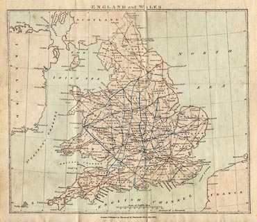
Map, England and Wales, index map to itineraries, scale
about 1 to 3800000, about 60 miles to 1 inch, bound in
Gray's New Book of Roads, 1824, published by Sherwood, Jones
and Co, Paternoster Road, London, 1824.
|
||

|
Gray 1824 | |
| inscription:- |
printed top
ENGLAND and WALES |
|
| inscription:- |
printed bottom
London : Published by Sherwood & Co. Paternoster Row. May 1824. |
|
| inscription:- |
printed back of title page
In the General Map of England and Wales, opposite the Title-page, the Cross Roads are drawn in blue lines, in contradistinction to the Direct Roads in red. The points d'appui, where the roads join, being thus rendered prominently distinct, the Route from any one part of the Kingdom to another may be easily traced, and referred to. |
|
| scale line:- | 100 miles = 42.2 mm | |
| wxh, sheet:- | 24.5x21cm | |
| wxh, map:- | 223x190mm | |
| scale:- | 1 to 3800000 ? (1 to 3813611 from scale line assuming modern mile) | |