 Bacon 1900s

|

|
|
|
item:- private collection (35) image:- © see bottom of page |
click to enlarge |
|
|
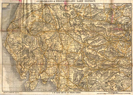
Map, lithograph printed on cotton? Cumberland and
Westmorland Lake District, or Waistcoat Pocket Map of Lake
District, scale about 5 miles to 1 inch, published by G W
Bacon and Co, 127 Strand, London, about 1900s?
|
||

|
Bacon 1900s | |
| map feature:- | folded & card cover & up is N & scale line & sea plain & coast shaded & rivers & lakes & relief & hill hachuring & parks & county & settlements & roads & railways & canals | |
| inscription:- |
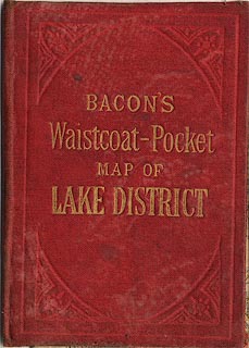
embossed cover
BACON'S / Waistcoat-Pocket / MAP OF / LAKE DISTRICT gold on red |
|
| inscription:- |
printed top
CUMBERLAND & WESTMORLAND LAKE DISTRICT |
|
| inscription:- |
printed bottom left, centre
Divided into 10 mile squares / G. W. BACON AND CO, 127, STRAND, LONDON. |
|
| scale line:- | 20 miles = 104.3 mm | |
| scale:- | 1 to 310000 ? (1 to 308599 from scale line) | |
| wxh, cover:- | 8x11cm | |
| wxh, folded:- | 7.5x11cm | |
| wxh, sheet:- | 43.5x31.5cm | |
| wxh, map:- | 410x282mm | |
|
||
|
||