 Ogilby 1675

|

|
|
|
item:- JandMN (83) image:- © see bottom of page |
click to enlarge |
|

|
menu with map segments and placename index | |
|
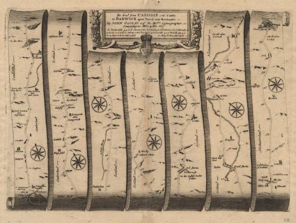
Road strip map, uncoloured engraving, the Road from
Carlisle to Barwick, scale about 1 inch to 1 mile, by John
Ogilby, London, 1675.
Includes from Carlisle, Cumberland; through Jedbrough ie Jedburgh, Kelso, Scotland; to Barwick ie Berwick upon Tweed, Northumberland. Published as plate 62 in Britannia. |
||
|
|
Ogilby 1675 | |
| map feature:- | scroll cartouche (?) & compass rose & up is destination & rivers & bridges & relief & hillocks & county & settlements & roads & road distances & distances from start | |
| inscription:- |
printed title cartouche, top centre
The Road from CARLISLE com~ Cumbr. / to BARWICK upon Tweed com~ Northumbr. / Containing 80 Miles 4 Fur : ... table of distances |
|
| scale:- | 1 to 63360 ? (nominal) | |
| wxh, sheet:- | 48x38.5cm | |
| wxh, plate:- | 451x321mm (?) | |
| wxh, map:- | 448x319mm (approx) | |
|
|
notes | |