 Ogilby 1675

|

|
|
|
item:- JandMN (73) image:- © see bottom of page |
click to enlarge |
|

|
menu with map segments and placename index | |
|
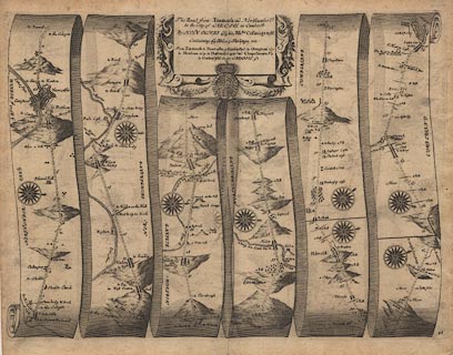
Road strip map, uncoloured engraving, the Road from
Tinmouth ... to Carlisle, scale about 1 inch to 1 mile, by
John Ogilby, London, 1675.
Includes from Tinmouth ie Tynemouth, through Newcastle, Corbridg, Hexham, and Haltwesell ie Haltwhistle, Northumberland; then via Corbey to Carlisle, Cumberland. Published as plate 86 in Britannia. |
||
|
|
Ogilby 1675 | |
| map feature:- | scroll cartouche (?) & compass rose & up is destination & rivers & bridges & relief & hillocks & county & settlements & roads & road distances & distances from start | |
| inscription:- |
printed title cartouche, top centre
The Road from Tinmouth in Northumberld. / to the City of CARLISLE in Cumberld. / By JOHN OGILBY Esq, his Maties. Cosmographr. / Containing 69 Miles 5 Furlongs, viz. / ... table of distances |
|
| scale:- | 1 to 63360 ? (nominal) | |
| wxh, sheet:- | 46.5x38cm | |
| wxh, plate:- | 446x334mm | |
| wxh, map:- | 440x328mm (approx) | |
|
|
notes | |