 Ogilby 1675

|

|
|
|
item:- JandMN (21) image:- © see bottom of page |
click to enlarge |
|

|
menu with map segments and placename index | |
|
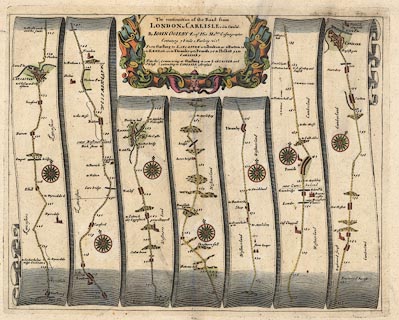
Road strip map, hand coloured engraving, continuation of
the Road from London to Carlisle, scale about 1 inch to 1
mile, by John Ogilby, London, 1675.
Includes from Garstang through Lancaster, Boulton, and Carnforth, Lancashire; then Burton, Kendal, Shap, Westmorland, and Penrith to Carlisle, Cumberland. Published as plate 38 in Britannia. |
||
|
|
Ogilby 1675 | |
| map feature:- | scroll cartouche (?) & compass rose & up is destination & rivers & bridges & relief & hillocks & parks & county & settlements & roads & road distances & distances from London | |
| inscription:- |
printed title cartouche, top centre
The continuation of the Road from / LONDON to CARLISLE com~ Cumbr~ / By JOHN OGILBY Esqr. His Maties. Cosmographer / Containing 78 Mile 1 Furlong (vizt) / ... table of distances |
|
| scale:- | 1 to 63360 ? (nominal) | |
| wxh, sheet:- | 51x42cm | |
| wxh, plate:- | 429x345mm | |
| wxh, map:- | 415x329mm | |
|
|
notes | |