 Clarke 1787 map

|

|
|
|
item:- private collection (10_8) image:- © see bottom of page |
click to enlarge |
|

|
menu with map squares and placename index | |
|
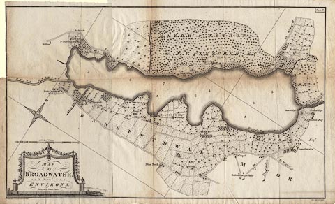
Map, A Map of Broadwater and its Environs, ie
Bassenthwaite Lake, scale about 6.5 ins to 1 mile, by James
Clarke, engraved by Neele, 352 Strand, published by James
Clarke, Penrith, Cumberland and in London etc, 1787.
Plate 8 in A Survey of the Lakes of Cumberland, Westmorland, and Lancashire. The maps has a north point with a fleur de lys for North marking the west point! and is, in a sense, up the wrong way. |
||
|
|
Clarke 1787 map | |
| map feature:- | monumental cartouche & north point (decorative, plus an irregular grid of N-S, E-W lines to show orientation? the North is the west point) & up is SW (roughly) & scale line & rivers & lakes & woods & county & settlements & roads | |
| inscription:- |
printed title cartouche, lower left
A / MAP / of / BROADWATER, / and its / ENVIRONS. / Surveyed by James Clarke. |
|
| inscription:- |
printed upper right
Plate 8. |
|
| inscription:- |
printed bottom left
Published Feby. 10th. 1787, by James Clarke, Penrith. |
|
| inscription:- |
printed bottom right
Neele sculpt. 352 Strand. |
|
| scale line:- | 70 chains = 142.5 mm | |
| scale:- | 1 to 9900 ? (1 to 9882 from scale line) | |
| wxh, sheet:- | 82.5x50cm | |
| wxh, folded:- | 22x31cm | |
| wxh, map:- | 774x466mm | |