 Clarke 1787 map

|

|
|
|
item:- private collection (26) image:- © see bottom of page |
click to enlarge |
|
|
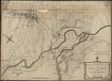
Map, A Map of the Town of Penrith and Country Adjacent,
scale about 10 ins to 1 mile, by James Clarke, engraved by S
J Neele, 352 Strand, published by James Clarke, Penrith,
Cumberland and in London etc, 1787.
Plate 1 in A Survey of the Lakes of Cumberland, Westmorland, and Lancashire. The map shows Penrith and the area out to Brougham to the south east. |
||

|
Clarke 1787 map | |
| map feature:- | picture frame cartouche & north point (decorative) & up is NE (about) & scale line & rivers & woods & county & settlements & roads | |
| inscription:- |
printed title cartouche, lower right
A MAP / of the TOWN OF PENRITH / and the / COUNTRY ADJACENT / Surveyed by / JAMES CLARKE. |
|
| inscription:- |
printed below title cartouche, lower right
S. J. Neele, Sculpt. 352 Strand, London |
|
| inscription:- |
printed upper right
Plate 1. |
|
| scale line:- | 35+2 chains = 116.5 mm | |
| scale:- | 1 to 6400 ? (1 to 6389 from scale line) | |
| wxh, sheet:- | 65x47cm | |
| wxh, map:- | 649x470mm | |