 Clarke 1787 map

|

|
|
|
item:- private collection (10_9) image:- © see bottom of page |
click to enlarge |
|

|
menu with map squares and placename index | |
|
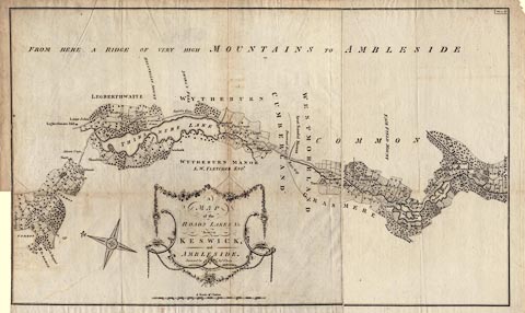
Map, A Map of the Roads Lakes etc between Keswick and
Ambleside, scale about 2.5 ins to 1 mile, by James Clarke,
engraved by S J Neele, 352 Strand, published by James
Clarke, Penrith, Cumberland and in London etc, 1787.
Plate 9 in A Survey of the Lakes of Cumberland, Westmorland, and Lancashire. The map is printed on two sheets of paper which were pasted together but have become unfixed; it is possible to see from the creases how the map was folded into the book. Shows the road from about Castlerigg to the edge of Ambleside, past Thirlmere Lake, Grasmere water, and Rydal Water. |
||
|
|
Clarke 1787 map | |
| map feature:- | floral cartouche & north point (decorative) & up is NE (roughly ENE) & scale line & rivers & lakes & woods & county & settlements & roads | |
| inscription:- |
printed title cartouche, lower centre
A / MAP / of the / ROADS LAKES &c / between / KESWICK / and / AMBLESIDE. / Surveyed by Jas. Clarke / S. J. Neele sculpt. No.352 Strand, London. |
|
| inscription:- |
printed upper right
Plate 9. |
|
| scale line:- | 220+20 chains = 177.7 mm | |
| scale:- | 1 to 27000 ? (1 to 27170 from scale line) | |
| wxh, sheet 1:- | 59.5x50cm | |
| wxh, sheet 2:- | 30x49.5 | |
| wxh, folded:- | 23x31cm | |
| wxh, map:- | 773x466mm | |