 Clarke 1787 map

|

|
|
|
item:- private collection (10_11) image:- © see bottom of page |
click to enlarge |
|

|
menu with map squares and placename index | |
|
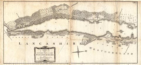
Map, A Map of the Southern Part of the Lake Winandermere
and its Environs, scale about 6.5 ins to 1 mile, by James
Clarke, engraved by Samuel John Neele, 352 Strand, published
by James Clarke, Penrith, Cumberland and in London etc,
1787.
Plate 11 in A Survey of the Lakes of Cumberland, Westmorland, and Lancashire. The map is printed on two sheets of paper bound into the book, facing each other, at their middle edges, folded to fit. |
||
|
|
Clarke 1787 map | |
| map feature:- | picture frame cartouche & north point (decorative) & up is W (just off) & scale line & rivers & lakes & woods & county & settlements & roads | |
| inscription:- |
printed title cartouche, lower left of centre
A MAP / of the / SOUTHERN PART of the LAKE / WINANDERMERE / and its / ENVIRONS / Surveyed by James Clarke. |
|
| inscription:- |
printed bottom left and right
Published Feby. 10th 1787 by James Clarke Penrith / Neele sculpt. 352 Strand London. |
|
| inscription:- |
printed upper right
Plate 11 |
|
| scale line:- | 70 chains = 141.3 mm | |
| scale:- | 1 to 10000 ? (1 to 9966 from scale line) | |
| wxh, sheet 1:- | 62x49.5cm | |
| wxh, sheet 2:- | 63.5x49.5cm | |
| wxh, folded:- | 25x30.5cm | |
| wxh, map:- | 994x467mm | |