 Clarke 1787 map

|

|
|
|
item:- private collection (10_4) image:- © see bottom of page |
click to enlarge |
|

|
menu with map squares and placename index | |
|
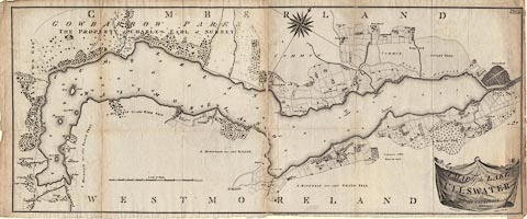
Map, A Map of the Lake Ullswater and its Environs, scale
about 6.5 ins to 1 mile, by James Clarke, engraved by S J
Neele, 352 Strand, published by James Clarke, Penrith,
Cumberland and in London etc, 1787.
Plate 4 in A Survey of the Lakes of Cumberland, Westmorland, and Lancashire. The map is printed on two sheets of paper which were pasted together on the binding tab, but have become unfixed; each sheet folded separately into the book. |
||
|
|
Clarke 1787 map | |
| map feature:- | drape cartouche & compass rose & up is NW (roughly) & scale line & rivers & lakes (form lines on coast) & woods & county & settlements & roads | |
| inscription:- |
printed title cartouche, lower right
A MAP of the LAKE / ULLSWATER / and its environs / Surveyed by / James Clarke |
|
| inscription:- |
printed above title cartouche, upper right
Engraved by S. Neele No 352 Strand London |
|
| inscription:- |
printed upper right
Plate 4 |
|
| inscription:- |
printed bottom
Published Feby. 10 1787, by James Clarke, Penrith. |
|
| scale line:- | 100 chains = 208.7 mm | |
| scale:- | 1 to 9600 ? (1 to 9639 from scale line) | |
| wxh, sheet 1:- | 61.5x50cm | |
| wxh, sheet 2:- | 60.5x49.5cm | |
| wxh, folded:- | 25x30cm | |
| wxh, map:- | 1083x467mm | |