 Bartholomew 1920s m

|

|
|
|
item:- JandMN (31) image:- © see bottom of page |
click to enlarge |
|
|
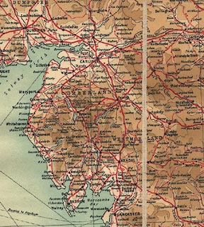
Contour Motoring Map of the British Isles, scale about
15.5 miles to 1 inch, by John Bartholomew and Son, The
Edinburgh Geographical Institute, 12 Duncan Street,
Edinburgh, Lothian, about 1920.
There are inset town plans of London, Manchester, Edinburgh, Glasgow and Dublin; and tables of distances from these cities. On the back cover are advertisements with index maps for half inch maps of England and Scotland. |
||

|
Bartholomew 1920s m | |
| map feature:- | up is N & scale line & lat and long scales & table of symbols & sea areas & sea tinted & coast line & rivers & relief & contours & layer colouring (0, 250, 500, 1000, 2000, and above 2000 feet) & spot heights & county & settlements & roads & road distances & shipping routes | |
| inscription:- |
printed right, above centre
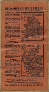
Cartographers to the King / BARTHOLOMEW'S / CONTOUR MOTORING MAP / OF THE / BRITISH ISLES / SHOWING THE BEST TOURING ROADS / WITH HEIGHTS AND DISTANCES / REDUCED BY PERMISSION FROM THE ORDNANCE SURVEY coat of arms, royal |
|
| inscription:- |
printed bottom left and right
THE EDINBURGH GEOGRAPHICAL INSTITUTE / JOHN BARTHOLOMEW & SON LTD. |
|
| inscription:- |
printed cover
BARTHOLOMEW'S / CONTOUR MOTORING MAP / OF THE / BRITISH ISLES / SHOWING THE BEST TOURING ROADS / Price 10/- net gold on beige |
|
| inscription:- |
printed above scale line
Scale - 1;1,000,000 or 16 English Miles to an Inch |
|
| scale line:- | 50 miles = 81.9 mm | |
| scale:- | 1 to 980000 ? (1 to 982505 from scale line) | |
| wxh, folded:- | 11.5x20.5cm | |
| wxh, sheet:- | 89.5x101.5cm | |
| wxh, map:- | 866x988mm (approx) | |
|
||
|
||