 Ramsay 1866

|

|
|
|
item:- Hampshire Museums : FA1997.72 image:- © see bottom of page |
click to enlarge |
|
|
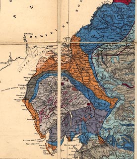
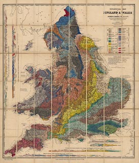
Map, Geological Map of England and Wales, scale about 12
miles to 1 inch, by Andrew C Ramsay, a local Director of the
Geological Survey, published by Edward Stanford, 6 Charing
Cross, London, 1866.
Among the sources given on the map are Professor Adam Sedgwick and Mr Ruthven for Cumberland Westmorland. |
||

|
Ramsay 1866 | |
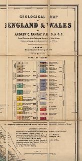
| map feature:- | sectioned for folding & mounted & folded & card cover & scale line & up is N & lat and long scales & lat and long grid & geology & stratigraphical column & geological section & county & settlements | |
| inscription:- |
printed top right
GEOLOGICAL MAP / OF / ENGLAND & WALES / BY / ANDREW C. RAMSAY, F.R.S.& G.S./ Local Director of the Geological Survey of Great Britain, / Professor of Geology in the Government School of Mines. / ... |
|
| inscription:- |
printed bottom
London; Published by Edward Stanford, 6 Charing Cross, January 15th. 1866 |
|
| scale line:- | 30 miles = 62.5 mm | |
| wxh, sheet:- | 85.5x101cm | |
| wxh, map:- | 809x942mm (including gaps) | |
| scale:- | 1 to 770000 ? (1 to 772485 from scale line assuming modern mile) | |
|
||
|
||
|
|
notes | |