 Unknown 1772

|

|
|
|
item:- Hampshire Museums : B2002.84.1 image:- © see bottom of page |
click to enlarge |
|
|
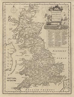
Map, uncoloured engraving, An Accurate Map of Great
Britain, scale about 40 miles to 1 inch, published by John
Cooke, Shakespear's Head, Pater Noster Row, London, 1772.
Included in The Complete English Traveller by Nathaniel Spencer |
||

|
Unknown 1772 | |
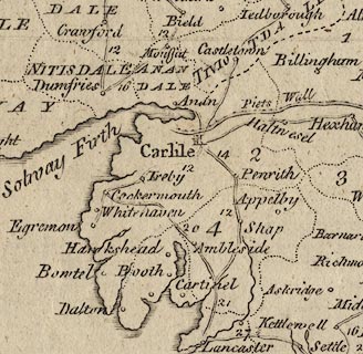
| map feature:- | monumental cartouche & compass rose & scale lines & lat and long scales & sea plain & coast shaded & county & table of data (counties) & settlements & roads | |
| inscription:- |
printed monumental cartouche, upper right
An Accurate MAP of / GREAT BRITAIN / from the latest & best / OBSERVATIONS |
|
| inscription:- |
printed above scale lines
English Miles 60 to a Degree / Scotch Miles 50 to a Degree |
|
| scale line:- | 60 miles = 38.2 mm | |
| scale line:- | 50 scottish miles = 37.4 mm | |
| wxh, sheet:- | 36.5X45cm | |
| wxh, plate:- | 311x413mm | |
| wxh, map:- | 294x397mm | |
| scale:- | 1 to 2500000 ? (1 to 2527765 from english scale line assuming a statute mile) | |
|
||