 Bartholomew 1900

|

|
|
|
item:- JandMN (37_2) image:- © see bottom of page |
click to enlarge |
|
|
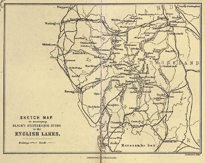
Sketch Map to accompany Black's Picturesque Guide to the
English Lakes, scale about 9 miles to 1 inch, by John
Bartholomew and Co, Edinburgh, Lothian, published by Adam
and Charles Black, London, 1900.
Printed on the front end papers of Black's Guide to the English Lakes, editor A R Hope Moncrieff, published by Adam and Charles Black, London, 23rd edn 1900. Railways are a prominent feature of the map. |
||

|
Bartholomew 1900 | |
| map feature:- | up is N & table of symbols & sea areas & sea plain & coast line & rivers & lakes & county & settlements & roads & railways | |
| inscription:- |
printed lower left
SKETCH MAP / to accompany / BLACK'S PICTURESQUE GUIDE / TO THE / ENGLISH LAKES. |
|
| inscription:- |
printed bottom, right and centre
Bartholomew Edinr. / Published by A & C Black, London. |
|
| wxh, map:- | 170x129mm | |
| scale:- | 1 to 580000 ? (crude estimate) | |