 Bartholomew 1900

|

|
|
|
item:- JandMN (37_1) image:- © see bottom of page |
click to enlarge |
|
|
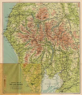
General Map of the Lake District, scale about 3 miles to
1 inch, by John Bartholomew and Co, Edinburgh, Lothian,
published by Adam and Charles Black, London, 1900.
Folded and inserted in a pocket at the back of Black's Guide to the English Lakes, editor A R Hope Moncrieff, published by Adam and Charles Black, London, 23rd edn 1900. |
||

|
Bartholomew 1900 | |
| map feature:- | colour printed & up is N & scale line & table of symbols & sea areas & sea tinted & coast line & rivers & lakes & relief & contours & layer colouring & table of heights & settlements & roads & railways | |
| inscription:- |
printed lower left
GENERAL MAP OF / THE LAKE DISTRICT |
|
| inscription:- |
printed bottom, left and right
COPYRIGHT / JOHN BARTHOLOMEW & CO., EDINR. |
|
| scale line:- | 6 miles = 49.9 mm | |
| wxh, sheet:- | 39.5x45.5cm | |
| wxh, map:- | 365x429mm | |
| scale:- | 1 to 190000 ? (1 to 193508 from scale line) | |