 West 1784 map

|

|
|
|
item:- Armitt Library : A1213.1 image:- © see bottom of page |
click to enlarge |
|
|
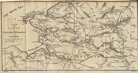
Map, uncoloured engraving, A Map of the Lakes in
Cumberland, Westmorland and Lancashire, scale about 3.5
miles to 1 inch, engraved by Paas, 53 Holborn, London, about
1784.
Inserted in Thomas West's Guide to the Lakes, 5th edition, 1793. |
||

|
West 1784 map | |
| map feature:- | north point (N fleur de lys, E cross) & up is W & scale line & table of symbols & sea plain & coast form lines & rivers & lakes & relief & hill hachuring & county & settlements & roads (routes in the guide with solid lines, other routes dotted) | |
| inscription:- |
printed left middle
A MAP / of the / LAKES / in / Cumberland, Westmorland / and / Lancashire. |
|
| inscription:- |
printed bottom left and right
Paas sculp. / No.53 Holborn |
|
| scale line:- | 5 miles = 35.2 mm | |
| wxh, sheet:- | 40x21.5cm | |
| wxh, map:- | 375x191mm | |
| scale:- | 1 to 230000 ? (from scale line) | |