 Luffman 1803

|

|
|

|
back to object record | |
| MAP FEATURES | ||
|
|
||
|
title cartouche
map maker |
Printed in a fairly plain cartouche fitted round the
border is:-
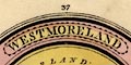
WESTMORELAND Printed at the bottom:- Sold by J. Luffman, 28, Little Bell Alley, Coleman Street, London. |
|
|
|
||
|
orientation
north point up is N |
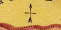
Printed upper middle is a north point; N-S line, E-W cross line, North marked by an arrow head, the flights at the south, The map is printed with North at the top of the sheet. |
|
|
|
||
|
scale line
scale |
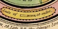
Peinted in a plain cartouche fitted round the bottom border is a curved:- Scale of 10 Miles chequered in 5 mile parts. The 10 miles = roughly 6.8 mm gives a map scale about 1 to 2366682 assuming a statute mile. The map scale is about:- 1 to 2400000 37 miles to 1 inch |
|
|
|
||
|
sea area
sea plain |
The tiny area of sea, in the Kent Estuary, is plain
|
|
|
|
||
|
coast line
coast form lines |
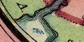
The short length of coast around the Kent Estuary is ephasized by form lines. |
|
|
|
||
| county |
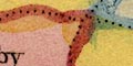
County boundaries are a dotted line. The adjacent counties are labelled, eg:- CUMBERLAND LANCASHIRE |
|
|
|
||
| settlements |
Settlements are marked by a circle or double circle.
differentiated by style of labelling. Only towns are shown,
and from the descriptive text these are meant to be market
towns.
|
|
| towns |
circle; labelled in italic lowercse text, eg:-
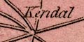
Kendal The de jure county town has a double cirlce and is labelled in upright lowercase text:- Appleby |
|
|
|
||
| roads |
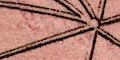
A network of roads is drawn by double lines. The north south route is included; and roads radiating from Kendal, the de facto county town; and the road east from Appleby. |
|
|
|
||
|
descriptive text
electoral data distances from London |
Printed in the left and right borders:-
Sends 4 Members to Parlmt. / Appleby Co. Town, 266 miles from London. The map is in a roundel at the top of page 37 of an atlas. Below there is descriptive text:- WESTMORELAND is 45 miles in length from east to west, and 33 in breadth from north to south. It is divided into 2 baronies, which contain 8 market towns, 26 parishes, 8,212 houses; and the population amounts to 41,617. The air is clear, sharp, and healthy; the soil various; the mountainous part very barren, and the vales altogether as fertile. Copper mines, and, it is said, some veins of gold, are in the mountains. The hams cured in this county are of excellent flavour. The principal rivers are the Eden, the Lone, and the Ken. It has also several fine lakes, the chief of which is Winander-Mere. The corresponding descriptive text for Cumberland, page 7 of the atlas, is:- CUMBERLAND is 75 miles in length from north to south, and upwards of 50 miles in breadth from east to west. It is divided into 5 wards, which contain 1 city, 14 market towns, 60 parishes, 22,445 houses; and its population amounts to 117,230. The air of this county is sharp, and the land, for the most part hilly, feeding large flocks of sheep. The principal productions are coal, lead, lapis callaminaris, and black lead, wild fowl, and salmon. The chief rivers are the Eden and the Derwent. The border text is:- Sends 6 Members to Parlmt. / Carlisle Co. Town, 301 Miles from London. |
|
Lakes Guides menu.