 Kitchin 1763

|

|
|

|
back to object record | |
| MAP FEATURES | ||
|
|
||
|
title cartouche
baroque cartouche map maker dedication |
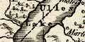
Printed lower right in a baroque title cartouche
decorated with foliage, a pastoral scene behind, is:-
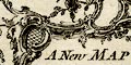
A New Map of WESTMORELAND, Drawn from the best Authorities: By Thos. Kitchin Geogr. Engraver to H.R.H. the Duke of York. |
|
|
|
||
|
orientation
compass rose up is N |
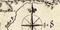
Printed lower right is a compass rose; circle, star points for cardinal directions, lines for half cardinal directions, North marked by a spear point fleur de lys, East marked by a cross. The map is printed with North at the top of the sheet. |
|
|
|
||
|
scale line
scale |
Printed lower right is a scale of:-
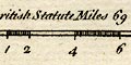
British Statute Miles 69 to a Degree. chequered to fit with markings labelled 1,2,4,6,10. The 10 miles = 42.0 mm gives a map scale 1 to 383177. The map scale is about:- 1 to 380000 6 miles to 1 inch |
|
|
|
||
|
lat and long scales
lat and long grid |
Printed in the map borders are scale of latitude and
longitude for a ?rectangular projection; chequered in
minutes, labelled at 10 minute intervals. The bottom scale
is labelled:-
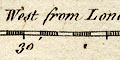
Longitude West from London. Reading from the scales the longitude, Kendal = 2d 50.9m W which suggests a prime meridian about 5 minutes E of Greenwich, which is unlikely. A latitude and longitude grid, a graticule, is printed at 1 degree intervals; on this map that means a line at the 2 and 3 degree meridian, but no parallel. The map includes from 2d 59m to 3d 20m W, from 54d 6m to 54d 44m N; the whole of Westmorland. |
|
|
|
||
| table of symbols |
Printed upper left are:-
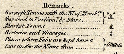
Remarks Borough Towns with the No. of Membrs. they send to Parliamt. by Stars ... [circle, buildings, tower, asterisks] Market Towns ... [circle, buildings, tower] Rectories and Vicarages ... [circle and cross (+)] Places where Fairs are kept have a Line under the Name thus ... Shapp [underlined] |
|
|
|
||
|
sea area
sea plain |
The small area of sea in the Leven and Kent Estuaries is
plain.
|
|
|
|
||
|
coast line
coast shaded foreshore |
The coast of the Leven and Kent Estuaries is emphasized by shading. Dotted lines outline an area of foreshore sands. |
|
|
|
||
|
rivers
bridges |
The lower reaches of larger rivers are drawn by double
line with a suggestion of stream lines, smaller rivers are a
wiggly line tapering upstream. Some rivers are labelled,
eg:-
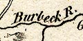
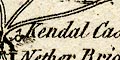
Burbeck R. Ken or Cam R. R. Brathy Swindale beck Bridges are implied where a road crosses and interrupts a stream. A few bridges are labelled, eg:- Emon Br. Nether Bridge [Kendal] Notice:- 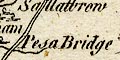
Pesa Bridge [Peasey Bridge] Levens bridge has no road but is marked with a double line across the stream As with other features, the labelling seems to be by chance, perhaps influenced by available space, perhaps by what was known or could be copied, rather than by choice of significance. |
|
|
|
||
| lakes |
Lakes are drawn by an outline with the shore shaded. Some
lakes are labelled:-
Ulles Lake Broad Water [Hawes Water] Haws Water [Hayes Water] Winander Mere Coniston Mere A scatter of islands is shown in Windermere. Other lakes might be recognized, eg:- Brothers Water Easedale Tarn Grasmere Kentmere Tarn [possible tarn WNW of Orton] |
|
|
|
||
|
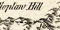
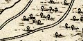
relief
hillocks |
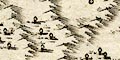
Relief is suggested by small hillock symbols shaded to the east. They are drawn in ranges in all sorts of available space, though the Eden Valley is left flat. Some hills are labelled, eg:- Kelloplaw Hill Bauderskarth Hill Wildboar Fell Wry Noes Head Helvillon Hill Murton Pike which are on the county boundary, and some others, eg:- Jeffery's Hill Whinfield Hill |
|
|
|
||
|
woods
trees forests |
Woodland is suggested by tin tree symbols, sometimes with
a suggestion of the underbrush. Some forests, usually with
trees, are labelled, eg:-
Wingfield Forest [Whinfell Forest] 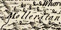
Mollerstang Forest and at least one without trees:- Fawsett Wood |
|
|
|
||
| parks |
Parks are drawn by a ring of fence palings, usually
enclosing woodland, and perhaps a circle for a house. Some
parks are labelled, eg:-
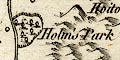
Holm's Park Siserge [with a castle symbol] |
|
|
|
||
| county |
The county boundary is a dashed line, continued alongside a boundary feature. Notice that Windermere is shown in Lancashire; the Glencoyne Beck boundary is shown far too far south on Ullswater. Adjacent counties, separated by a dotted line, are labelled, eg:- PART OF CUMBERLAND DURHAM Some boundary features are shown, labelled, such as the hills already listed and Hollow Mill Cross, Dunmail Raise Stones, Rey Cross, and also:- 3 Shire Stones upon Wry Nose Head marked by three standing stones, the:- Birkstone by the Lancaster road, marked by a stone; and the:- County Stone marked by a standing stone at the meet of Westmorland with Lancashire and Yorkshire. A little is drawn outwith the county for the sake of continuity of roads. |
|
|
|
||
|
settlements
fairs |
Settlements are marked by a circle with added elements,
some explained in the Remarks, further differentiated by
style of labelling.
An underlined name implies that a fair is held there, at Shapp, Milthorp, which seems rather few. |
|
| towns |
circle, buildings, tower; labelled in upright lowercase
text, eg:-
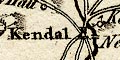
Kendal Orton Market towns according to the Remarks, and in italic block caps, as the de jure county town:- APPLEBY with two attached stars to show it is a borough sending 2 members to Parliament. |
|
| villages |
circle, cross; labelled in italic, lowercase text,
eg:-
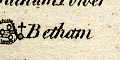
Betham Shapp or Shaw [underlined, a fair] Morland |
|
| hamlets |
circle; labelled in italic, lowercase text, eg:-
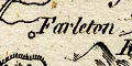
Farleton Knipe |
|
|
|
||
| roads |
A network of roads is drawn by double line. It includes the 'Ogilby' routes from Lancaster to Carlisle through Burton, Kendal, Shap, Penrith, and the branch from Kendal to Keswick, along with various other roads. The Ambleside to Patterdale route passing the head of Kentmere and Hawes Water is shown as on other maps of this period. Road destinations are sometimes given at the county boundary, eg:- to Barnard castle to Lancaster In other places the road is extended into the adjacent county, as the roads to Penrith and Keswick. |
|
|
|
||
| miscellaneous | ||
|
|
||
| beacons |
Labelled on a hill NE of Orton is:-
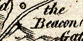
The Beacon which might be marked by a building on the hill top. |
|
|
|
||
|
antiquities
stones |
Various stones are marked on the county boundary:-
3 Shire Stones upon Wry Nose Head County Stone Dunmail Raise Stones Birkstone And a group of standing stones at the road junction south of Shap is labelled:- 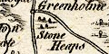
Stone Heaps |
|
|
|
||
| crosses |
Crosses at the county boundary are marked by a cross (+)
and labelled:-
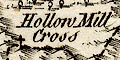
Hollow Mill Cross Rey Cross |
|
|
|
||
|
wells
springs |
A circle south of Ullswater is labelled:-
St. Patrick's Well |
|
|
|
||
| castles |
Castles and some large houses are marked by a circle with
a flag, not described in the table of symbols, but used on
other maps. Examples:-
Kendal Castle Whelp Ca. Pendragon Cas. Thornthwate Hall |
|
|
|
||
| peat mosses |
Some vegetation other than woodland is shown. South of
Kellet by the Lune is an area of dotted shading (?)
labelled:-
Lonebridge Fen A similar area beside the Kent Estuary, SW of Beetham is labelled:- 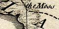
The Moss |
|
|
|
||
|
mines
lead mines copper mines |
On the hills SW of Milburn Forest are:-
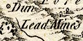
Lead Mines and more SE of Murton Pike. At the head of Langdale are:- Copper Mines |
|
Lakes Guides menu.