 Kitchin 1750s

|

|
|

|
back to object record | |
| MAP FEATURES | ||
|
|
||
|
title cartouche
map maker publisher |
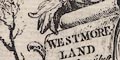
Printed in a fancy title cartouche lower right:- WESTMORELAND Drawn from ye best Authorities and Regulated by Astronl. Observatns. By T. Kitchin Geogr. on a roll of cloth hanging from a bolt on a scrollwork stand, with other bolts of cloth, ?felt hats, trees and bushes, and a background of mountain pikes. Printed at the top:- For the London Magazine and at the bottom:- Printed for R. Baldwin Junr. at the Rose in Pater Noster Row. |
|
|
|
||
| coat of arms |
Engraved upper left in a baroque cartouche is:-
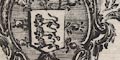
THE ARMS OF APPLEBY the de jure county town. |
|
|
|
||
| table of symbols |
Printed left centre is an:-
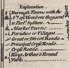
Explanation. [circle, buildings, tower, stars] Borough Towns with the No. of Members they send to Parlt. by Stars. [circle, buildings, tower] Market Towns. [circle] [circle with spike] Parishes or Villages. [double line, light bold] Great or Direct Roads. [double line, light light] Principal Cross Roads. [single line] Cross Roads. a King Arthur's Round Table. |
|
|
|
||
|
orientation
compass rose up is N |
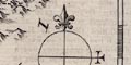
Printed right centre is a minimal compass rose; circle, lines for cardinal directions, North marked by a fleur de lys, east marked by a cross. The map is printed with North at the top of the sheet. |
|
|
|
||
|
scale line
scale |
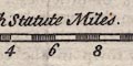
Printed right centre is a scale of:- British Statute Miles. chequered in miles, labelled at 1,2,4,6 .... The 10 miles = 32.2 mm gives a scale 1 to 499796. The map scale is about:- 1 to 500000 8 miles to 1 inch a statute mile) |
|
|
|
||
|
lat and long
lat and long scales |
Printed in the map borders are scales of latitude and longitude for a ?trapezoidal projection; chequered in 2 minute intervals, labelled at 10 minute intervals. At the 20 degree latitude mark is also engraved:- 54 Deg. & 20 Min. North Latitude as an exact degree does not appear on the scale. And by the 3 degree longitude mark is:- Deg. W. Longit. from London. The map includes from 1d 50m to 3d 22m W, from 54d 8m to 54d 40m N; all of Westmorland. From the scale the longitude, Kendal = 2d 52m W which suggests a prime meridian 3 degrees west of Greenwich, perhaps St Paul's. |
|
|
|
||
|
sea area
sea plain |
The small area of sea at the river mouths by the Cartmel
peninsula is plain.
|
|
|
|
||
|
coast line
coast form lines |
The small amount of coast line on the river estuaries by the Cartmel peninsula is engraved with form lines for emphasis. |
|
|
|
||
|
rivers
bridges |
Rivers are drawn by wiggly line tapering upstream. Some rivers are labelled, eg:- Ken R Lone R. Burrow R. The major rivers and ?larger tributaries are shown. 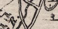
Bridges are implied where a road crosses and interrupts a stream. This is not apparent where the road is a single line, but in some of those instances the bridge is drawn by a double line across the stream, examples at Low Burrow Bridge and Appleby.
At Sedbergh a bridge is marked this way though there is no road. Most bridges are not named, but notice:- Burrow Br |
|
|
|
||
| lakes |
Lakes are drawn in outline with form lines, the larger
lakes labelled:-
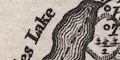
Ulles Lake Winander Mere Other lakes can be recognised:- Brothers Water Hayes Water Haweswater Rydal Water Grasmere Kentmere Tarn Easedale Tarn (?) |
|
|
|
||
|
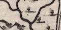
relief
hillocks |
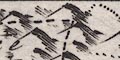
Relief is indicated by small hillocks shaded to the east.
These are scattered liberally over the county, keeping the
Eden Valley clear of hills, and other river valleys less
hilly. One or two hillocks are larger, and might be
labelled, eg:-
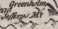
Jefferys Mt. Helvillin Hill Whinfield Hill Murton P Roman Fell On the road north from Kendal a hillock is drawn under the road in the style of strip road maps to indicate an ascent, labelled:- Betome Hill A valley might be labelled, eg:- Stanmore Dale |
|
|
|
||
| beacons |
A larger hillock is labelled:-
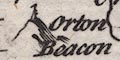
Orton Beacon and has the beacon shown by a post etc. The detail is not clear but could be a drawing of post, ladder and cresset. |
|
|
|
||
|
woods
forests trees |
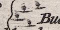
Woodland is indicated by tiny tree symbols. These are scattered about liberally, not particularly grouped. There are usually a tree or two in parks. A couple of forests are labelled:- Milburne Forrest Lune For: the first with, the second without trees, which is not wrong. |
|
|
|
||
| parks |
Parks are drawn in outline with fence palings, a few trees inside, and perhaps buildings. A park might be labelled, eg:- Brigster P |
|
|
|
||
| county |
The county boundary of Westmorland is a dashed line; adjacent counties are separated by a fine dotted line. The adjacent counties are labelled, eg:- LANCASHIRE CUMBERLAND At the meet on a hill top, of Lancashire, Yorkshire and Westmorland, is labelled:- County Stone A very little is engraved outwith the county for the sake of continuity, Sedbergh, Dent, Cartmel and a few landscape features. |
|
|
|
||
|
settlements
electoral data |
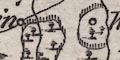
Settlements are positioned by a circle, with added
elements, differentiated by style of labelling.
|
|
| towns |
circle, buildings, tower and perhaps attached stars;
labelled in upright lowercase text, eg:-
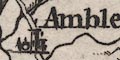
Ambleside Kendal Orton Stanley [Staveley] Or labelled in upright block caps:- APPLEBY which is the county town, and has two stars indicating it returns two members to Parliament. |
|
| villages |
circle with a vestigial building and a spike on top;
labelled in italic lowercase text, eg:-
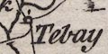
Tebay Shap Kellath [Kellet] Sedberg |
|
| hamlets |
circle; labelled in italic lowercase text, eg:-
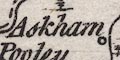
Askham Underbarrow Horse H [Horse House] |
|
|
The imposed grading as town, village, hamlet does not
match present day conceptions of places.
Some place names are abbreviated, needing local knowledge for their understanding, eg:- Brough S [Brough Sowerby] Farlton K [Farleton Knott, labelling a hamlet not the hill] Crosby Rav. [Crosby Ravensworth] Other abbreviations are more obvious:- H for Hall or House, Hd Head, M Mere, Ch Church, etc. |
||
|
|
||
| roads |
A umber of roads are drawn by double or single line. The double line might be dotted, probably indicating an unfenced margin. Two main routes are shown:- from the south, Lancashire; through Burton, to and around Kendal, then Shap, Westmorland; to Penrith and northward, Cumberland. from Kendal, through Staveley, Ambleside, Westmorland; crossing NNW at Dunmail Raise Stones into Cumberland. The various minor roads involve Kirkby Lonsdale, Tebay, Orton, Cartmel, Appleby, Brough, Kirkby Steven, and routes eastward into Yorkshire. |
|
|
|
||
| miscellaneous | ||
|
|
||
|
mines
lead mines coal mines |
A label by hillocks in Stanmore Del declares:-
Cole Pitts and in the hills north of brough are:- 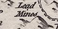
Lead Mines |
|
|
|
||
| crosses |
A cross is drawn on a larger hillock on the county
boundary, labelled:-
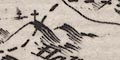
Hallowmill Cross |
|
|
|
||
|
stones
antiquities |
The road from Orton meets the Kendal to Shap road
at:-
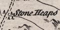
Stone Heaps which are drawn as standing stones. And similar stones are labelled:- Dunmail Raise Stones At the meet on a hill top, of Lancashire, Yorkshire and Westmorland, is labelled:- County Stone |
|
|
|
||
|
antiquities
earthworks |
A letter:-
a in a circle north of Clifton is explained in the table of symbols as:- King Arthur's Round Table |
|
Lakes Guides menu.