 Jansson 1646

|

|
|

|
back to object record | |
| MAP FEATURES | ||
|
|
||
|
title cartouche
scroll cartouche map maker |
Printed in a scroll cartouche, upper left:-
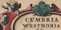
CUMBRIA & WESTMORIA. Vulgo Cumberland & Westmorland. Printed lower left of centre:- Amstelodami Apud Joannem Janssonium |
|
|
|
||
|
coat of arms
heraldic border |
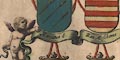
Lower right there is a group of coats of arms of:- RAPHE NEVILL. John D. of Bedford John D of Somerset John de Foix with decorative ribbons and cherubs. Upper right is another group:- The Earles of Carlile Marcatus E. Ran. Meschines Andrew Harkley and a blank shield. Withe scale line lower left is a scene on a hill side, a young man with a hawk, various fowls, a young lady with a ?crook, and sheep, and the coat of arms of:- HENRY CLIFFORD EARLE |
|
|
|
||
|
orientation
labelled borders compass rose rhumb lines up is N |
Printed in the four map borders, in Latin, are:-
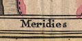
Septentrio / Oriens / Meridies / Occidens 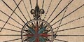
On the left is a compass rose; circle, star points for cardinal, half cardinal, and false points, lines for by points, North marked by a fleur de lys, East marked by a cross. All the directions are continued across the sea area as rhumb lines, the false point lines dotted. The map is printed with North at the top of the sheet. |
|
|
|
||
|
scale line
scale |
Printed lower left is a scale of:-
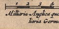
Milliaria Anglica quorum quatuor unum Milliaria Germanicum constituunt The 10 miles = 68.1 mm gives a scale 1 to 236321 wrongly assuming a statute mile. The map scale is about:0- 1 to 240000 3.5 miles to 1 inch |
|
|
|
||
|
sea area
sea plain ships swash lettering |
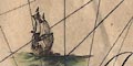
The sea area is plain, with rhumb lines from the compass rose. It is labelled, in swash lettering:- IRISH SEA and in ordinary style:- Itunae Baye [Eden Estuary / Solway Firth] There are a couple of square rigged ships in the sea. Both seem to have three masts, fore sail and fore topsail, main sail and main top sail, and a lateen sail. The stern of one is square. |
|
|
|
||
|
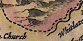
coast line
coast shaded coast form lines headlands harbours foreshore sea moire effect |
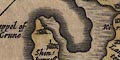
The coast line is emphasized by shading which is drawn along the coast line and the outer margin of foreshore shallows. The coast line above the shallows is also shaded, less strongly, and the area of the foreshore is decorated with a sea moire effect. River estuaries have stream or form lines. The sands are mostly unlabelled, but see:- Ken Sandes [Lancaster Sands] A headland might be noticed, eg:- S. Bees head One harbour is noticed:- Derwenfote haven at Workington. |
|
|
|
||
|
rivers
bridges |
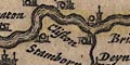
Rivers are drawn by a wiggly double line tapering to a wiggly single line tapering upstream. Some rivers are labelled, eg:- Eden flude Cauda fl. [Caldew] Duddon flud. Barrow Flu. [Burrow Beck] This makes it quite clear what the abbreviations stand for. Although Jansson uses Latin he is a northern European uses the germanic term flood for rivers. Bridges are marked by a double line crossing a stream (there are no roads). Some bridges are labelled, eg:- 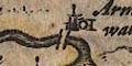
Levens bridge Newe Bridge [Newby Bridge] |
|
|
|
||
| lakes |
Lakes are drawn by an outline, with the shore shaded, and the body of the lake pecked. Some are labelled:- Brodwater [Ennerdale Water] Denok fl Thurlmyre fl. Ulles fl. Wynander mere flud Other lakes and tarns might be recognized, with some degree of uncertainty, eg:- Bassenthwaite Lake Bleaberry Tarn Brothers Water Burnmoor Tarn Buttermere Coniston Water Crummock Water Derwent Water Lowes Water Rydal Water Wast Water Islands are shown in Derwent Water and Rydal Water. |
|
|
|
||
|
relief
hillocks |
Relief is indicated by hillocks shaded to the east. These
sometimes appear in groups, and sometimes in ranges, as the
Pennines. Occasional hills are drawn larger as at:-
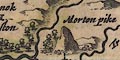
Morton pike Skiddow hill The Spije Cragg and the hills at the head of Borrowdale and Wasdale. Notice the convention of writing ij for y. Some lesser hillocks are also labelled, eg:- Hevillon hill |
|
|
|
||
|
woods
trees forests |
Tree symbols indicate woodland in parks and forests. The
latter might be labelled, eg:-
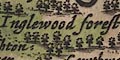
Inglewood Forest Copeland Forest There are other patches of woodland, for example north of Kendal, and at Hoffe south of Appleby. |
|
|
|
||
| parks |
Parks are drawn by a ring of fence palings, and mostly include tree symbols, and are tinted green. A park might have no trees or decoration as at Barren wode park. A park might be labelled, eg:- Brigster park Uffay park or be named by its great house as at:- Grastock cast. |
|
|
|
||
| county |
County boundaries are a dashed line, continued alongside a boundary feature. There is a tint on the inside of each county boundary; Cumberland yellow, Westmorland yellow, Lancashire pink, Yorkshire green, Northumberland pink, and Scotland green. This is not the best effort at colouring. The county areas are labelled, eg:- WESTMORLAND PART OF NORTHUMBERLAND The county tint is also applied along some rivers and round some lakes, which probably has no significance. In Ullswater and Windermere, where the boundary is wrong, the dashed line and tint do not run together. Two standing stones are marked at the meet of three counties, labelled:- 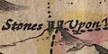
Shire Stones Upon Wrynose A large hillock south of Dent has a label by it:- 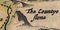
The Countye stone Features are shown outwith the two counties for the sake of continuity and to fill space. The corner of Yorkshire around Sedbergh is plotted fairly fully, as is the High Furness are of Lancashire. Some 'areas' are labelled, eg:- Gilsland Copeland Furness fells |
|
|
|
||
|
settlements
town walls |
Settlements are marked by a circle with added elements,
further differentiated by style of labelling.
|
|
| cities |
circle, towers, town wall; labelled in upright block
caps:-
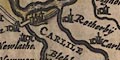
CARLILE |
|
| towns |
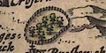
circle, buildings, towers, perhaps a few fence palings
for a wall? labelled in upright lowercase text, eg:-
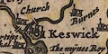
Keswick Kendal |
|
|
villages
hamlets houses castles |
circle, buildings, tower; labelled in italic lowercase
text, eg:-
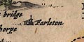
Farleton Shapp Chapollon The last is Chapel on the Ings ie Ings, the other part of the placename 'The Ings' is a label floating detached to the south of the village. A house might be marked and labelled in the same way, eg:- Grariggehall also a castle, which might have a flag on the tower, eg:- Millum cast. |
|
|
|
||
| miscellaneous | ||
|
|
||
| beacons |
Two beacons are marked by a post with side bars - could
these be a post with ladder rungs? but no obvious cresset.
They are labelled:-
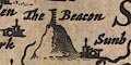
The Beacon [Orton Beacon] Mewtoo Becon |
|
|
|
||
| stones |
Two standing stones are marked, labelled:-
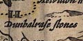
Dunbalrase stones as well as the Three Shire Stones already noted. |
|
|
|
||
| crosses |
A cross is drawn on a slightly larger hillock near
Pendragon, labelled:-
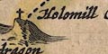
Holomill Crosse |
|
|
|
||
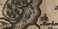
| mines |
At Keswick is an added label:-
The mijnes Royall where the headquarters and smelter of the Company of Mines Royal was. On the fells between Uldale and Cladbeck ie Caldbeck, drawn on a large hillock, are two bold dots labelled:- 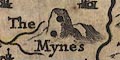
The mynes |
|
|
|
||
| tents |
A simple tent symbol is marked on
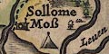
Sollome Moss representing the Battle of Solway Moss. There is another at Penrith. |
|
|
|
||
|
antiquities
roman sites roman wall |
A stone wall is drawn from Boulness ie Bowness on Solway,
through Carlile, and north and east, labelled:-
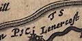
THE PICTS WALL |
|
Lakes Guides menu.