 Hall 1820

|

|
|

|
back to object record | |
| MAP FEATURES | ||
|
|
||
|
title
engraver publisher |
Printed at the top of the page, side of the map, in a plain cartouche is:- WESTMORELAND Printed at the bottom of the page, side of the map, left and right:- Pub. by S. Leigh, 18, Strand. / Sidy. Hall sculpt. |
|
|
|
||
|
orientation
compass rose up is N |
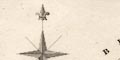
Within the map borders the map is printed sideways, clearly labelled to be read that way. Printed upper left of the map is a compass rose; no circle, star points for cardinal directions, lines for half cardinal directions, North marked by a spear head or fleur de lys. The map has North at the top. |
|
|
|
||
|
scale line
scale |
Printed lower left of the map is a scale of:-
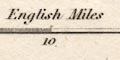
English Miles chequered in 1 miles intervals to 5, in fives to ten, then in tens. The 20 miles = 35.1 mm gives a scale 1 to 917005 assuming a statute mile. The map scale is about:- 1 to 920000 14.5 miles to 1 inch |
|
|
|
||
|
coast line
coast shaded |
The tiny bit of coast line shown in the Kent Estuary is shaded for emphasis. |
|
|
|
||
|
rivers
bridges |
Rivers are drawn by wiggly line tapering upstream. A few rivers are labelled, eg:- Lune R. Eden R. Bridges are implied where a road crosses and interrupts a stream. |
|
|
|
||
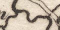
| lakes |
Lakes are drawn in outline, shaded. One is labelled:-
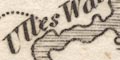
Ulles Water other might be recognised:- Windermere and perhaps:- Easedale Tarn [?] Cow Green Reservoir [now] Some other larger lakes are not noticed, perhaps squeezed out by placename labels. |
|
|
|
||
| relief |
Relief is not indicated.
|
|
|
|
||
| parks |
Some parks are drawn in rough outline with fence palings, the interior pecked. Some parks are labelled, eg:- Levens Pk. Wharton Park |
|
|
|
||
| county |
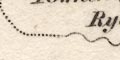
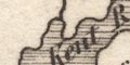
The county boundary is a dotted line, which is not continued where another features serves. A section is missing between Windermere and the coast. Adjacent counties are labelled, eg:- CUMBERLAND though not divided, and Durham is missed. very little is shown outwith the county; Sedbergh on the minor roads from Kendal and Kirkby Lonsdale to Kirkby Stephen. |
|
|
|
||
|
settlements
electoral data distances from London |
Settlements are marked by a circle, differentiated by
style of labelling.
|
|
| towns |
circle; labelled in upright lowercase text, eg:-
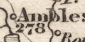
Ambleside / 278 Shap / 277 Kirkby Stephen / 278 except:- 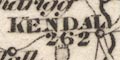
KENDAL / 262 APPLEBY / 279 [with 2 stars] Kendal is the de facto county town; Appleby the de jure county town, and sends two members to Parliament. |
|
|
villages
hamlets houses |
circle; labelled in italic lowercase text, eg:
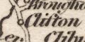
Clifton Selside Docker Nook [Longsleddale] |
|
|
|
||
| roads |
Roads are drawn by double or single line, for greater and lesser roads. The two major routes are:- from the south; through Burton, Kendal, Shap, Westmorland; and north through Penrith, Cumberland. from Bowes in the east; through Brough and Appleby, to join the N-S route south of the River Lowther, Westmorland. The road from Kendal through Ambleside to the north west is shown as a minor route. Road destinations for the greater roads might be given at the county boundary,eg:- To Penrith |
|
Lakes Guides menu.