 Ships and Boats on the 1576 Saxton Map of
Cumberland and Westmoreland
Ships and Boats on the 1576 Saxton Map of
Cumberland and Westmoreland

|

|
|
|

|
NOTES from SAXTON'S MAP of WESTMORLAND and CUMBERLAND, 1576 | ||
|
Ships and Boats on the 1576 Saxton Map of Cumberland and Westmoreland
Ian Friel MA, PhD, FSA
Writer & Historian
2009
Ships and boats were a feature of many 16th century charts, coastal maps and atlases. There is little doubt that most of the vessels depicted were generic illustrations, rather than portraits of specific ships. There are a few exceptions to this, such as the 1580 map of the siege of Smerwick Bay in Ireland, which appears to show the actual images of the English warships involved (NMM 1988, p.74) Christopher Saxton's map of Cumberland and Westmoreland (1576) shows six vessels, one three-master (number 1) one two-master (number 2) , two single-masted vessels (3 and 4) and two fishing boats (5 and 6). One of the striking features of these ships is that all are engaged in trade or fishing. None are shown in combat, or firing cannon in an aimless display of aggression, and none of them have their hulls pierced for gunports (a sign of a ship built for fighting). Piracy was endemic in English waters in the 16th century, and it was not at all unusual for even very small ships to carry weapons of some kind. Both the three-master and the two-master on the map have ports in their superstructures, which could suggest the presence of cannon, but this could imply no more than a legitimate capability of self-defence. The overall image is one of ships engaged in purposeful activity, and is found in some of Saxton's other county maps, such as those of Hampshire and Sussex. The Hampshire map for example, shows the Solent and Southampton Water filled with trading vessels rather than naval shipping. At the time, these waters were probably among the most heavily-defended areas in Europe, a naval base. The ships on Saxton's maps portray a range of types, both in terms of rig and hull form. The Hampshire map includes a lot of sprit-rigged one-masters, their distinctive sails spread out on one side of the mast like bedsheets drying in the wind, but there is also a big multi-masted trading carrack of a type that was probably already obsolescent when Saxon drew the map. The Cumberland and Westmoreland map vessels show an even greater variety. Number (1)
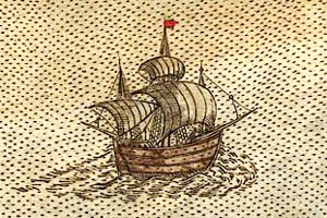 is a three-master, although its foremast has been shown inaccurately behind the billowing mainsail, probably for artistic reasons - three-masted 'ship-rigged' ships had square sails on the fore and mainmasts, and a triangular lateen sail on the mizzenmast at the stern. It has square main- and maintopsails, and a lateen sail at the mizzen. The ship has a bowsprit protruding from the bow (used to help in support the foremast and to facilitate sailhandling) and an 'outligger' projecting from the stern, which was used to help give extra purchase for the rigging which controlled the lateen sail. The three-masted rig was probably the commonest kind used by seagoing vessels in the 16th century, but documents and other pictures of the time show that other two- and one-masted rigs were also used. Number (2)
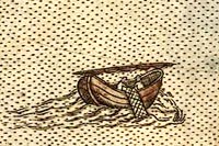
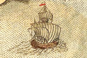 is a two-masted vessel, apparently sailing close-hauled (i.e. into the wind), with its 'square' fore and mainsails spread taut. The mainmast has a top (a circular, railed platform used for lookouts and defence) and a topmast and square topsail, with a small pennant or wind-vane at the masthead. The two single-masted, square-sailed ships are also of a kind found in other sources of the period (numbers 3 and 4).
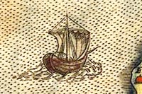
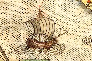 They represent a type that was commonplace in Northern Europe until the 15th century, when multi-masted vessels began to supplant them. The craft shown here seem to have little or no superstructure, and the real vessels which inspired them may have been little more than large open boats. That said, one-masters were certainly used in both coastal and international trade. Each of the two one-masted fishing boats is shown with its single mast down, lying from stem to stern (numbers 5 and 6).
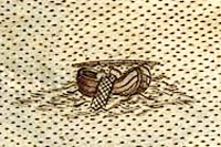
 Masts were unshipped in this fashion to create more space for handling nets, but in larger vessels the mainmast would have been lowered towards the stern, to rest in a specially-constructed support. The fact that this is not the case with these two boats suggests that they were intended to represent very small craft. Their hull-shapes have a significant rise from amidships towards the stem and stern (known as 'sheer'). A pronounced sheer can make a hull stronger, but it was also commonplace for 16th-century English artists to depict small boats in this way, and the form of these craft may have owed more to artistic tradition than observation. The hull details of the vessels shown by Saxton are not very realistic, but these are very small ship-pictures created in a period when ship imagery could vary from the realistic to the fanciful. One gets the impression that Christopher Saxton had a real understanding of the variations between different ship-types. Whilst his coastal maps are not a technical gazetteer of the merchant shipping and fishing boats found in English waters on the 1570s, they give us a more realistic picture of these kinds of vessels than might at first be imagined. Beyond that, they convey an image of a maritime nation engaged in 'honourable trade', belying the traditional representation of Elizabethan 'sea dogs' as no more than pirates or fighters. |
|||
|
References : 1988: Armada 1588-1988 (The Official Catalogue): National Maritime Museum (Greenwich, London) |
|||
|
|
|||
Lakes Guides menu.