 Feltham 1803 map 2

|

|
|

|
back to object record | |
| MAP FEATURES | ||
|
|
||
|
orientation
up is N |
The map is printed with North at the top of the sheet.
The sheet was tipped into its book sideways, zigzag
folded.
|
|
|
|
||
|
scale line
scale |
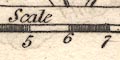
Printed at the bottom is a:- Scale / Miles chequered and labelled at 1 mile intervals. The 10 miles = 49.9 mm gives a scale 1 to 322514 assuming a statute mile. The map scale is about:- 1 to 320000 5 miles to 1 inch |
|
|
|
||
|
sea area
sea plain |
The tiny bit of sea at Bootle is plain.
|
|
|
|
||
|
coast line
coast shaded |
The tiny bit of coast line at Bootle is shaded, as is the estuary of the River Irt. |
|
|
|
||
|
rivers
bridges |
Rivers are drawn by a wiggly line tapering upstream; lots
of tributaries are shown. Some rivers are labelled, eg:-
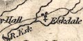
R. Esk Derwent R. Ken R. Bridges are mostly not noticed, but implied where a road crosses and interrupts a stream. Smaller roads, a single line, don't make a visible interruption. At least one bridge is labelled:- 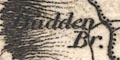
Dudden Br. |
|
|
|
||
| lakes |
Lakes are drawn in outline with form lines. Islands are
shown in some lakes, for example Windermere and Derwent
Water. Most large and some small lakes are labelled,:-
Bassenthwaite Burnmoor Tarn Buttermere Water Coniston Water Crummock Water Derwent Water Easthwaite Water Elter Water Ennerdale Water Halls Water [Haweswater] Lowes Water Over water Skeggles Water Thirle Meer 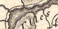
Ulles Water Wast Water Winander Mere Also recognisable are:- Brothers Water Rydal Water Grasmere ... |
|
|
|
||
|
relief
hill hachuring |
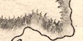
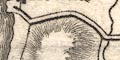
A limited amount of relief is indicated by hill hachuring. The hills are not labelled, except:- Dow Crags The hachuring is not entirely even but what emphasis is given does not provide a good overall impression of the relief of The Lakes. 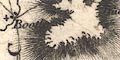
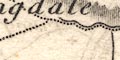
At the back of Bootle bold hachures mark higher hills (not in the right place to be Scawfell). A valley might be labelled,eg:- Great Langdale but notice that:- Martin's Dale labels a high area. |
|
|
|
||
| forests |
Woodland is not indicated but at least on forest area is
labelled:-
Copeland Forest |
|
|
|
||
| parks |
Parks might be drawn in outline with fence palings, the
interior dotted, perhaps with tree symbols. For
example:-
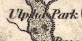
Ulpha Park Others might just be labelled, eg:- Graystock Park |
|
|
|
||
| county |
County boundaries are a fine dotted line which is continued alongside rivers or other boundary features. The county areas are labelled, eg:- WESTMORELAND |
|
|
|
||
| settlements |
Settlements are marked by a block or blocks, and/or a
cross (+) for a church, differentiated by style of
labelling.
|
|
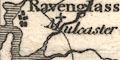
| towns |
group of blocks; labelled in upright lowercase text,
eg:-
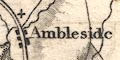
Ambleside Kendal Ravenglass |
|
|
villages
hamlets |
a block or two, or cross, or nothing; labelled in italic
lowercase text, eg:-
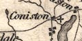
Coniston [blocks, cross] Staveley [blocks] Fallday [block] Ulpha [cross] Rydal [nothing] Other map features are labelled with this style of lettering. |
|
|
|
||
| roads |
A network of roads is drawn by double line, light bold, or single line. The larger roads are perhaps turnpike roads. the single lines might represent no more than a route from place to place, perhaps a track. |
|
Lakes Guides menu.