 Feltham 1803 map 1

|

|
|

|
back to object record | |
| MAP FEATURES | ||
|
The map is a road map of the whole country showing little
more than an outline of the England and Wales, settlements
and main roads.
|
||
|
|
||
| title |
Printed upper right:-
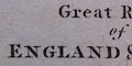
The Great Roads of ENGLAND & WALES connecting the Watering Places. Printed top left and right:- PL.1. / To Face the Title Page. |
|
|
|
||
|
scale line
scale |
The map has a:-
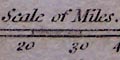
Scale of Miles. chequered and labelled at 10 mile intervals. The 50 miles = 20.7 mm giving a scale 1 to 3887304 assuming a statute mile. The map scale is about:- 1 to 3900000 61 miles to 1 inch |
|
|
|
||
|
sea area
sea plain |
The sea area is plain.
|
|
|
|
||
|
coast line
coast shaded |

The coast line is emphasised by shading. |
|
|
|
||
| settlements |
Settlements are located by a circle, and all labelled in
italic lowercase text.
|
|
|
cities
towns villages |
circle; labelled in italic lowercase text, eg:-
Carlisle Appleby 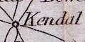
Kendal Cartmel |
|
|
|
||
| roads |
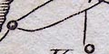
A network of roads is drawn by a single line. These are the 'Great Roads'. |
|
| Westmorland and Cumberland Places | ||
|
The following places in Westmorland, Cumberland etc, now
Cumbria, are included on the map:-
|
||
|
|
||
Appleby |
||
Burton |
||
Carlisle |
||
Cartmel |
||
Cockermouth |
||
Dalton |
||
Egremont |
||
Hawkshead |
||
Holm [?] |
||
Kendal |
||
Keswick |
||
Longtown |
||
Penrith |
||
Ravenglass |
||
Whitehaven |
||
Wigton |
||
Lakes Guides menu.