 Dury 1764

|

|
|

|
back to object record | |
| MAP FEATURES | ||
|
These notes have a strong bias towards an interest in The
Lakes.
|
||
|
|
||
|
orientation
compass rose up is N |
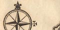
Printed middle left is a compass rose; circle, star points for cardinal directions, lines for half cardinal directions, North marked by a fleur de lys, East marked by a cross. The map is printed with North at the top of the sheet. |
|
|
|
||
| scale |
The map has no scale line, but an estimate can be got
from the scale of latitude. 1 degree Latitude = 79.5mm gives
a scale 1 to 1400230. The map scale is about:-
scale: 1 to 1400000 22 miles to 1 inch |
|
|
|
||
| lat and long scales |
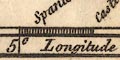
Printed in the map borders are scales of latitude and longitude for a slanted rectangular projection; chequered in 15 minute intervals, labelled at degrees. The bottom scale is labelled:- Longitude West from London The map includes from 2d 45m to 5d 15m W, from 53d 50m to 55d 0m N; part of the Irish Sea, Isle of Man, part of the SW coast of Scotland, Solway Firth, Cumberland and north Lancashire coasts. |
|
|
|
||
|
sea area
sea plain |
The sea area is plain. Some sea areas are labelled:-
IRISH SEA Solway Frith |
|
|
|
||
|
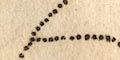
coast line
coast form lines sandbanks foreshore headlands |
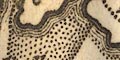
The coast line is emphasised by form lines. Foreshore areas and some sandbanks are marked by areas of dotting. Some headlands are labelled, eg:- St. Bees Hd. Various islands are shown. |
|
|
|
||
| rivers |
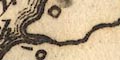
Some rivers are noticed for a short way inland from the coast, drawn by wiggly line tapering upstream. A few rivers are labelled at their outfall to the sea, eg:- Darwent R Irt R Others might be recognised. |
|
|
|
||
| lakes |
Some lakes are shown up rivers, reminiscent of a medieval style of plotting these features. It is possible to recognise:- Derwent Water Coniston Water Wast Water Ennerdale Water |
|
|
|
||
| relief |
No relief is indicated, but one hill (at least) is
labelled:-
Clint Hill north of St Bees Head. |
|
|
|
||
| county |
The county boundaries are a dotted line. County areas are labelled, eg:- WESTMORELAND CUMBERLAND |
|
|
|
||
| settlements |
Settlements on the coast are noticed, marked by a circle
with added elements, further differentiated by style of
labelling.
|
|
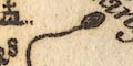
| cities |
circle, buildings and towers, and a cross above; labelled
in italic block caps:-
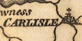
CARLISLE Notice that Lancaster is not marked as a city. |
|
| towns |
circle, building and a cross above; labelled in italic
lowercase text, eg:-
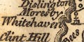
Whitehaven Egremont |
|
| villages |
circle; labelled in italic lowercase text, eg:-
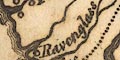
Ravenglass Oldmowborow Grune ch. |
|
|
The italic lowercase lettering is used for other map
features.
|
||
Lakes Guides menu.