 Cole and Roper 1805

|

|
|

|
back to object record | |
| MAP FEATURES | ||
|
|
||
| title cartouche |
Printed in a title cartouche top centre:-
WESTMORELAND Printed bottom, left, centre and right:- Engraved by J. Roper from a drawing by G. Cole. / London: Published by Vernor, Hood & Sharpe, Poultry. March 1st. 1807. / to accompany the Beauties of England & Wales. Printed lower centre is:- Drawn and Engraved under the direction of E. W. Brayley. The paper has a watermark:- J WHATMAN / 1805 |
|
|
|
||
| table of symbols |
Printed lower left is an:-
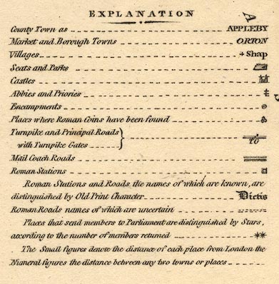
EXPLANATION County Town as ... APPLEBY [upright block caps] Market and Borough Towns ... ORTON [italic block caps] Villages ... + Shap [upright lowercase] Seats and Parks ... [outline of fence palings] Castles ... [building with twin towers] Abbies and Priories ... [Cross of Loraine] Encampments ... [double circle] Places where Roman Coin have been found ... [three coins?] Turnpike and Principal Roads with Turnpike Gates ... [double line, light bold] TG Mail Coach Roads ... [double line, feathered] Roman Stations ... [double square] Roman Stations and Roads the names of which are known, are distinguished by Old print Character ... Victis [English Black Letter font] Roman Roads names of which are uncertain ... [double line, dotted] Places that send members to Parliament are distinguished by Stars, according to the number of members returned ... [two asterisks] The small figures denote the distance of each place from London the Numeral figures the distance between any two towns or places ... |
|
|
|
||
|
orientation
compass rose up is N |
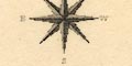
Printed upper left is a compass rose; no circle, star points for cardinal and half cardinal directions, North marked by a spear point, labels W, S, E. The labels for E and W are the wrong way round, perhaps an engravers error with mirror imaging his work. The map is printed with North at the top of the sheet. |
|
|
|
||
|
scale line
scale |
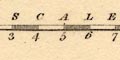
Printed lower right is a:- SCALE / Miles chequered and labelled in miles. The 10 miles = 42.5 mm gives a scale 1 to 378669 assuming a statute mile. The map scale is about:- 1 to 380000 6 miles to 1 inch |
|
|
|
||
|
lat and long
lat and long scales |
Printed in the map borders are scales of Latitude and longitude for a rectangular projection; chequered and labelled across in 10 minute intervals, up and down in 5 minutes. The map includes from 1d 58m to 3d 28m W, from 54d 10m to 54d 42m N. Notice that the latitude scale is correctly labelled at 54d 15m, but the minute north of that are 5, 10, ... 25 instead of 20, 25, ... 40. Judging from the scales the approximate longitude, Kendal = 2d 48m This suggests a prime meridian about 3d W of Greenwich, perhaps St Paul's? |
|
|
|
||
|
rivers
bridges fords ferries |
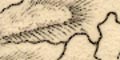
Rivers are drawn by wiggly line tapering upstream. A broad part of a river might have a double line with form lines. Some rivers are labelled, eg:- Winster River Ken River Crowdundle Beck The county's major rivers and some tributaries are shown. A few waterfalls are labelled, eg:- 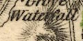
Waterfall on a stream above Ambleside. Bridges are implied where a road crosses and interrupts a stream. Some bridges on the county boundary are labelled, eg:- 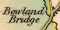
Bowland Bridge Rother Fell Bridge Hell Gill Bridge Notice the crossing of the Eden upstream of Countess Pillar, labelled:- Ford even though it is drawn as a bridge. The Windermere Ferry is marked by a dotted line, labelled:- Ferry |
|
|
|
||
| lakes |
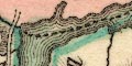
Lakes are drawn in outline with form lines, tinted blue. Some lakes are labelled:- Ulles Water Winander Mere Skeggles water Blea Tarn [Langdale] Grasmere Water Rydale water Elter water Broader Water [Brothers water] Hays water The Tarn [Kentmere Tarn] Hawes Water Some other lakes can be recognised:- Loughrigg Tarn Angle Tarn Decoy Pond [Lowther] The great island in Windermere is shown. |
|
|
|
||
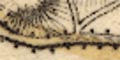
|
relief
hill hachuring |
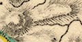
Relief is indicated by hill hachuring. No overall sense of the shape of the county is made, except it i mostly hilly with some river plains. Some hills are labelled, eg:- Orton Scar Helvelyn Wry Nose Farlton Knot Green Fell A valley might be labelled, eg:- Westleddale Dibdale |
|
|
|
||
| forests |
No tree symbols indicate woodland, but some forests are
labelled, eg:-
Mallerstang Forest Milbourn Forest |
|
|
|
||
| parks |
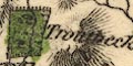
Some parks are drawn in outline with fence palings, the interior dotted, perhaps with a tree symbol or two, tinted green. The park might be labelled, eg:- Wharton Park Steer park [Brigsteer] or might be recognised from a house or settlement, as at Lowther. |
|
|
|
||
| county |
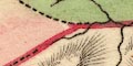
County boundaries are a dashed line. The boundary of Westmorland is emphasised by the tints of each of the adjacent counties: Cumberland pink, Lancashire green, Yorkshire yellow, Durham green. Notice also the colouring of the ward (hundred) boundaries. Adjacent counties are labelled, eg:- LANCASHIRE CUMBERLAND A few features are plotted outwith the county for the sake of continuity of roads, as at Sedbergh and Penrith. |
|
|
|
||
|
wards
table of wards |
Wards, comparable to hundreds; their boundaries are a dotted line which is narrowly tinted with a colour, red, green, blue, yellow, for each of the wards. These tints conflict, unnecessarily, with the colourings of the counties. It would have been a subtle task, though possible, to colour the four wards and the adjacent counties so that none of the four colours touched. The wards are labelled with a number that keys to a table of wards. WARDS 1 East Ward 2 West ward 3 Kendale 4 Lonsdale |
|
|
|
||
|
settlements
electoral data distances from London |
Settlements are marked by a group of blocks, perhaps a
cross for a church, differentiated by style of labelling;
see the table of symbols.
|
|
| towns |
group of blocks; labelled in italic block caps, eg:-
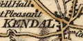
KENDAL ORTON / 275 3/4 AMBLESIDE / 275 The county town has upright block caps:- APPLEBY / by Kendal 285 3/4 / by Brough 269 3/4 The distances are miles from London. Kendal's distances are tabulated lower right of the map sheet:- to Kendal by Lancaster 261 3/4 --- by Settle ... 264 1/2 --- by Milthorpe ... 263 1/4 |
|
|
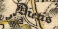
villages
hamlets |
block or blocks, perhaps just a cross; labelled in italic
lowercase text, eg:-
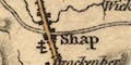
Shap Staveley Crosswaite |
|
|
|
||
|
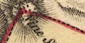
roads
turnpike roads post roads road distances |
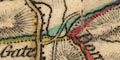
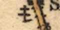
A network of roads is drawn by double lines in various style for post roads, turnpikes and lesser roads as described in the table of symbols. Turnpike roads have light bold lines and are tinted yellow. Post roads have a feathered edge. The post roads are:- from the south, Lancashire; through Burton, Preston Patrick, Kendal, Shap, Westmorland; to Penrith and northward, Cumberland. This is part of the London to Carlisle road. from the eats, Yorkshire; through Brough, Appleby, Kirkby Thore, and Brougham, Westmorland, joining the Shap to Penrith road at Eamont. Turnpike gates are marked by a bar across a road, labelled, eg:- 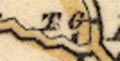
T G on the Kendal to Ambleside road just north of the turning to Windermere Ferry. Distances from town to town are given by mixed roman and arabic numbers by the road, eg:- 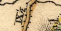
IX 1/2 [Burton to Kendal] XXVI [Kendal to Shap] Road destinations outwith the county are given at the county boundaries, eg:- from Lancaster 11 M from Kirkby Stephen to Askrig 20 Miles from Egremont & Whitehaven |
|
|
|
||
| miscellaneous | ||
|
|
||
| religious houses |
An abbey might be marked by a double cross, as by
Shap:-
|
|
|
|
||
| stones |
An indeterminate mark by the Ambleside to Keswick road is
labelled:-
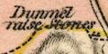
Dunmel raise Stones East of mallerstang Forest, on the county boundary is:- Lady's Pillar marked by an upright block. |
|
|
|
||
| memorials |
Labelled by the road at Brougham is:-
Countess Pillar |
|
|
|
||
|
mines
coal mines lead mines |
A label south of Stainmoor Forest says:-
Coal Pits Three circles by Dufton fell, near Howgill, are labelled:- Lead Mines |
|
|
|
||
| stones |
A group of blocks, nine? is labelled:-
Nine Standards At a bend in the county boundary East of Nateby. |
|
|
|
||
|
antiquities
roman sites roman towns |
Roman places are labelled in English Black Letter,
eg:-
Victis [roman fort at Ambleside] Brovonacae [Kirkby Thore?] Brocavum [Brougham] Gallacum [roman fort N of Appleby] [ ]erterae [Brough] Concangium [roman fort S of Kendal] |
|
|
|
||
|
antiquities
earthworks |
The earthwork at Eamont is drawn as a tumulus (modern
symbol, circle and hachures) labelled:-
King Arthur's Round Table |
|
|
|
||
|
antiquities
roman roads |
A roman road might be shown by a double dotted line. This might run with a modern road. See, for example, the road from the east to Penrith. For much of this the double dotted lines are drawn within the double lines of the road, occasionally following their own route. This is labelled in English Black Letter:- Maiden Way Various roman camps are marked along its route. |
|
Lakes Guides menu.