 Cobbett 1832

|

|
|

|
back to object record | |
| MAP FEATURES | ||
|
|
||
|
title
map maker |
A title is printed on each map in a plain cartouche,
lower left:-
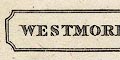
WESTMORELAND CUMBERLAND Printed at the bottom of each sheet:- Drawn & Engraved for Cobbett's Geographical Dictionary of England and Wales. |
|
|
|
||
|
orientation
north point up is NE up is N |
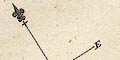
Each map has a north point; N-S line, E-W line, North marked by a fleur de lys spear point, all four directions labelled with a letter, N E S W. The map of Westmorland is printed with NE at the top of the sheet, Cumberland with North at the top of the sheet. But; in both instances the distortion lessens the significance of the exact orientation. |
|
|
|
||
| scale |
There is no indication of scale; very rough estimates
have been made, ignoring distortions. The Westmorland map
scale is about:-
1 to 460000 7 miles to 1 inch The Cumberland map scale is about:- 1 to 1200000 20 miles to 1 inch |
|
|
|
||
| county |
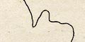
The county boundary is a solid line. The maps show very little except the inaccurate outline and a few towns. |
|
|
|
||
| settlements |
Settlements are marked by a dot and circle, except
Carlisle with a double circle, differentiated by style of
labelling.
|
|
| cities |
double circle; labelled in upright lowercase text:-
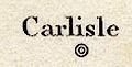
Carlisle |
|
| towns |
dot and circle; labelled in italic lowercase text,
eg:-
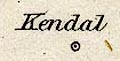
Kendal Keswick Also see:- |
|
Lakes Guides menu.