 Clarke 1787

|

|
|

|
back to object record | |
| Clarke 1787, Map Folding | ||
|
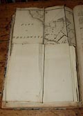
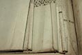
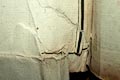
One example of James Clarke's Survey of the Lakes ... 2nd
edn 1789 includes the dozen tipped in plates, some of which
are very large, and are folded. As is quite usual, these
plates are all in bad condition, creased and torn. The
library has inherited a nasty problem which will not be
resolved by traditional rebinding which would relax, flatten
and reinforce the maps, but then refold them and bind them
back in to be damaged again.
|
||
|
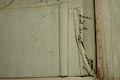
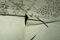
Having often seen the traditional approach result in damage
to maps after conservation I am coming to the belief that
the maps and book must be separated; the maps must be stored
flat after being conserved, the book rebound without them.
But the two should not be separated, they should be stored
together in a suitable box on the library shelf.
|
||
|
||
|
||
|
||
|
||
|
||

|
||
|
||
Lakes Guides menu.