 Cary 1790

|

|
|

|
back to object record | |
| MAP FEATURES | ||
|
|
||
|
title
map maker engraver publisher |
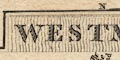
Printed in a plain title cartouche at the top:- WESTMORELAND and printed either side of the title cartouche:- By J. Cary. / Engraver. Printed at the bottom:- London Published Sepr. 1. 1792 by J. Cary No.181 Strand |
|
|
|
||
|
orientation
compass rose up is E |
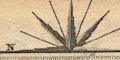
Printed at the top is half a compass rose atop the title cartouche, a recognisable Cary pattern; no circle, star points for cardinal and half cardinal directions, lines for false points, letters N and S label north and south (a letter E might have been trimmed off). The map is printed with east at the top of the sheet. |
|
|
|
||
|
scale line
scale |
Printed lower middle is a:-
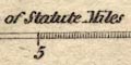
Scale of Statute Miles chequered and labelled at 5 mile intervals. The 10 miles = 22.1 mm gives a scale 1 to 728210. The map scale is about:- 1 to 730000 11.5 miles to 1 inch |
|
|
|
||
|
coast line
coast form lines |
The tiny area of sea shown is part of the Kent Estuary, where coast form lines fill the space. |
|
|
|
||
|
rivers
bridges ferries |
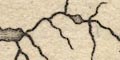
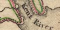
Rivers are drawn by wiggly line tapering inland. Tributaries appear to more decorative than informative. Some main rivers are labelled, eg:- Kent River Lune R. Trout Beck Bridges are implied where a road crosses and interrupts a stream, but this might just be a convention of the engraver. A few bridges are noticed, labelled. Where the Trout Beck crosses the road beside Windermere lake is:- Trout Beck Br and where the Kendal to Sedbergh road crosses the Lune is:- 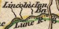
Lincolns Inn Br. No ferry is marked or labelled, but the roads from Kendal and from Hawkshead at the narrows of lake Windermere clearly suggest the ferry that is there. |
|
|
|
||
| lakes |
Lakes are drawn in outline with form lines, and the
larger lakes are labelled:-
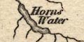
Horns Water [Haweswater] Winander Mere Ulles Water Some other lakes are recognisable, eg:- Rydal Water ?Grasmere Esthwaite Water Brothers Water Skeggles Water Kentmere Tarn decoy pond, Lowther |
|
|
|
||
| relief |
No relief is shown.
|
|
|
|
||
| parks |
A few parks are drawn in outline with fence palings, the
interior dotted, perhaps with a tree symbol or two. On the
map studied parks are tinted green. Most of the parks are
labelled, eg:-
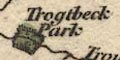
Trogtbeck Park Levens Pa Wharton Park |
|
|
|
||
| county |
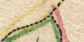
County boundaries are a dotted line. On the map studied there is a thin line of tint along the inside of the border of each county; Westmorland green, Lancashire pink, Cumberland blue, Durham pink, Yorkshire yellow. Adjacent counties are labelled, eg:- YORK SHIRE CUMBERLAND A few features are engraved outwith the county for the sake of continuity. |
|
|
|
||
|
settlements
electoral data |
Settlements are marked by a block or two, differentiated
by style of labelling.
|
|
| towns |
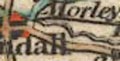
blocks; labelled in upright lowercase text, eg:-
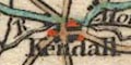
Kendall Orton Kirkby Stephen Appleby has two asterisks indicating it is a borough sending two members to Parliament. On the map studied the towns are tinted red. |
|
| villages |
a block; labelled in italic lowercase text, eg:-
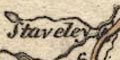
Staveley Shap This stye of lettering is used generally for features on the map. |
|
|
|
||
|
roads
road distances distances from London table of distances |
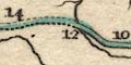
A network of roads is drawn by double line, usually light bold which is a common convention for turnpike roads in the late 18th century. The map comes out of an atlas of turnpike roads. Lines are solid or dotted, for fenced or unfenced routes. On the map studied the roads are tinted green or yellow. The green roads may be the more important routes:- from the south and Lancaster, Lancashire; through Burton in Kendal, Endmoor, Kendall, Gateside, Demmings, Shap, Brains, Thrimby, Clifton, Westmoreland; to Penrith, Cumberland and on towards Carlisle - the Great North Road. from a junction on the Great North Road, south of the Eamont and Lowther rivers, through Temple Sowerby, Kirkbythore, Crackenthorpe, Appleby, Brough, Westmoreland; and east to Bowes etc, - the London Road. Destinations outwith the county are given, at the county border, eg:- from Carlisle / the Great North Road to Lancaster London &c to Richmond to London by Settle The road edns in each adjacent county are labelled with a tiny letter, a, b, ... to link the road to its continuation on the relevant county sheet. Road distances are labelled by the roads at 2 mile intervals, from town to town. Kendal is the start place for many of the routes. Printed at the bottom is a list of distances from London:- London to Ambleside 281 M. Kendal 257 Burton 246 Kirkby Lonsdale 255 Oxton [ie Orton] 279 Appleby 267 Kirkby Stephen 281 Brough 259 Sedbergh 263 |
|
|
|
||
| canals |
If you look hard you will see a canal drawn by a bold curvy line from the south, ending at Kendal. This is the:- Lancaster Canal |
|
Lakes Guides menu.