 Cary 1794

|

|
|

|
back to object record | |
| General Arrangement | ||
|
The map is conceived a single sheet with a border around,
but is engraved and printed as a series of separate pages. A
general map, page 4, shows England and Wales, and a little
of Scotland, divided into 9x9 sheets numbered from bottom
left to top right.
|
||
|
So, for example, the title page of the 'atlas' comes from
part of the top edge of the map, and includes the longitude
scale either side of 1 degree. This is sheet 78; upper right
of centre of the whole.
|
||
|
The sheets which cover Cumbria are: Westmorland - 49, 50,
58, and 59; Cumberland - 49, 57, 58, 59, 67, and 68;
Lancashire North of the Sands - 49; Yorkshire, Sedbergh area
- 59.
|
||
| MAP FEATURES | ||
|
The map features described are mostly those on the one
sheet, plate 58, of the whole map.
|
||
|
|
||
|
title
map maker |
The individual sheet has no title. Printed at the
bottom:-
Published by J. Cary, June 1st. 1794. Printed on sheet 5 of the whole map of the 1824 edition, lower centre, is:- London: Published April 1st. 1816 by J. CARY, Engraver & map seller, No.181 Strand. The conflicting dates warns that particular sheets in an edition might be left over stock of an earlier edition or printing. |
|
|
|
||
| index map |
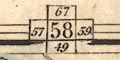
Printed in the top border of the map is a guide diagram to adjacent pages, 67 to the North, 57 West, 59 East, 49 South. |
|
|
|
||
| table of symbols |
Printed on page 3:-
EXPLANATIONS. The figures in the plan at the top of each page shew the manner in which the plates are to be united / The middle figure denotes the number of the plate, and the figures at the top and bottom, explain its connection North and South, and those at the sides, East and West [various diagrams] Turnpike Roads, thro~ enclosed countries ... [double line, solid, bold light] Do. thro~ unenclosed do. ... [double line, dotted, bold light] Bye Roads are marked by closer lines, as ... [double line, narrower] NB. The Turnpike Roads to and from London, are distinguished by the letters LR, which will be a sufficient guide for uniting those roads, and the junctions of all the other turnpike Roads are shewn by figures of reference. Churches and Chapels ... [cross (+)] Cities ... [blocks and a large cross] Borough Towns are described by stars, the number of which denote the number of members returned by each borough, as ... POOLE [upright block caps][blocks, 2 asterisks] Market Towns: their names are engraved in Capitals as LEEDS 193 [upright block caps] / NB. The distance of each town from London is prefixed to each. Rectories & Vicarages ... their naems are engraved in roman Print, as ... Hendon [upright lowercase] Hills ... [hachures] Parks ... [outline with fence palings, interior pecked, trees] Rivers ... [wiggly lines tapering upstream] Navigable Canals ... [triple line, light bold light] / NB. Several of the Canals laid down on this Map are not yet copmpleted, but their courses are delineated accoding to the plan prescribed by the acts of parliament relating to each such canal. They were inserted at the request of many gentlemen who are interested in those canals, and with a hope, that an accurate delineation of them might gratify the curious as well as be useful to the publick. Directions for tracing any Route. / Suppose the road from York to London is required to be traced? See the Index for a reference to the situation of York, and look for the pages in the small general map, which shew the direct course to London. That map, observe, is divided into squares which correspond with the pages. Or, trace the road agreeably to the plan at the top of each map, taking notice, that the road to London is to be known where the letters LR are placed to read towards London. The road from the capital to any other place in the map, may be found by adopting either of those rules reversed; but it must be observed, that the letters denoting London Road which lie East of the Meridian of London are, unavoidably, made to read from, & not towards, that place. Instances in that case partialy occur in p.16,17,18,25,26,27,34,35,36,69. On this page is the index diagram showing this is sheet 72, upper right of the whole, connecting to sheets 81, 71, 63. |
|
|
|
||
|
orientation
compass rose up is N |
The individual sheet has no indicator of orientation. The
map is printed with North at the top of the sheet.
Printed on sheet 69 of the whole map, upper middle, is a compass rose; no circle, star points for cardinal and half cardinal directions, North marked by a fleur de lys, labels E S W. |
|
|
|
||
|
scale line
scale |
Printed on page 4 in the atlas is a scale line of:-
British Statute Miles 69 1/2 to a Degree chequered and labelled at 1 mile intervals to 5, then at 5 mile intervals. The 30 miles = 152.1 mm gives a scale 1 to 317425 assuming a statute mile. The map scale is about:- 1 to 320000 5 miles to 1 inch This page is sheet 63, upper right. |
|
|
|
||
|
lat and long
lat and long scales |
The border of the whole map, not the Cumbria sheet, has
scales of latitude and longitude for a trapezoidal
projection; chequered in 5 minutes, labelled at 15 minutes.
Acroos sheets 6 and 7 in the bottom border of the whole is
label:-
Longitude West from London |
|
|
|
||
|
sea area
sea shaded |
The sea area off Cumberland is shaded. Two areas are
labelled:-
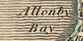
Allonby Bay SOLWAY FIRTH |
|
|
|
||
|
coast line
coast shaded |
The coast line is emphasised by additional shading, executed with an attractive shaded effect. Incidentally, because it is also the county boundary, the coast line has tints green and red. |
|
|
|
||
|
rivers
bridges |
Rivers are drawn by wiggly line tapering upstream. Wider parts of rivers, near the coast, have a double line with form or stream lines. Some rivers are labelled, eg:- Dudden R. Lune or Loyne R Eden Bridges are implied where a road crosses and interrupts and stream. 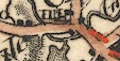
Some bridges are labelled, eg:- Bouland Br Lowther Br. Sebergham Br The bridge over Thirlmere is shown. |
|
|
|
||
|
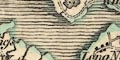
relief
hill hachuring |
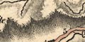
Relief is indicated by hill hachuring, which is executed in a manner that suggests as series of plateaus and valleys, but no overall picture of the shape of the district is made. Some hill areas are labelled, eg:- Langdale Fells [N of Howgill] Kirkstone Dod Fell Helvelin Cold Fell Pike But, it is not always clear what is being labelled: Helvelin seems to have a town symbol, Nan Bield likewise. It would be an uncertain task to match prominences to any of the areas of hachures. |
|
|
|
||
| forests |
Some forests are labelled, without tree symbols (which is
not wrong), eg:-
COPELAND FOREST KING'S FOREST of GELTSDALE Whinfell Forest [E of Penrith] |
|
|
|
||
| lakes |
Lakes are drawn in outline with form lines, and might be labelled:- BASSENTHWAITE WATER Broader Water [Brothers Water] Burnmoor Tarn Buttermire Lake Coniston Water CRUMMOCK WATER DERWENT WATER Devock L Easthwaite Water Elter Water ENNERDALE WATER HALLS WATER [Haweswater] Lowse Water Over Water Skeggles Water Talkin Tarn Tarn Wadling Thirle Meer Tindale Tarn ULLES WATER WAST WATER WINANDER MERE Other lakes and tarns can be recognised:- Easedale Tarn Grasmere Hayeswater Rydal Water Stickle Tarn [perhaps] Whinfell Tarn Whins Pond [E of Penrith] [by Jenkincrag] [gone? SW of Bowness on Solway] and a few very smaller tarns ... |
|
|
|
||
| parks |
Parks are drawn by an outline with fence palings, the
interior dotted, with tree and bush symbols, tinted green.
There might be a house or castle. The park might be
labelled, or named by a house, eg:-
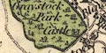
Greystock Park [castle symbol, labelled Castle] Clea Hall [house symbol] Killington Park [house just beside] |
|
|
|
||
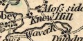
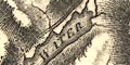
| county |
County boundaries are a dotted line. A narrow line of tint is applied on the inside for each county; Cumberland blue, Westmorland green, Lancashire red, Yorkshire yellow, on this page. The county areas are labelled, eg:- WESTMORE[ ] CUMBERLAN[ ] disappearing off to the next sheet. |
|
|
|
||
|
settlements
electoral data distances from London |
Settlements are marked by block or blocks, and/or drawing
of a church, house, or castle, differentiated by style of
labelling.
|
|
| cities |
group of blocks, tinted red; labelled in upright block
caps:-
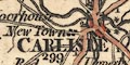
CARLISLE / 299 The figure giving the distance from London. Carlisle town walls are drawn (I think), and there are drawings of castle and church. A large cross symbol perhaps indicates a cathedral. Two attached asterisks indicate that two members are sent to Parliament. |
|
| towns |
group of blocks, tinted red; labelled in upright block
caps, eg:-
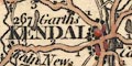
KENDAL / 267 PENRITH / 281 ORTON / 271 There might be a church or castle, and perhaps asterisks for members of Parliament, as at Cockermouth. |
|
| villages |
block or blocks, and a church; labelled in upright
lowercase text, eg:-
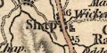
Shap Dacre Winster |
|
| hamlets |
block or blocks; labelled in italic lowercase text,
eg:-
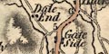
Dale End Brigsteer Stavely This style of labelling is used for all sorts of other map features. |
|
|
|
||
|
roads
road distances turnpike roads toll gates |
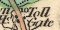
A network of roads is drawn by double lines, wider and narrow. Lines are solid or dotted, presumably for fenced and unfenced margins. The broad, main, roads have light bold lines, and are tinted yellow/brown. Distances from town to town are given by figures by the road at mile intervals. Toll gates might be indicated, but not reliably; see at Town Head, north of Grasmere on the Ambleside to Keswick road:- Toll Gate shown by the label only. At the map edges the main roads are labelled: top edge, left to right:- LR 1 right edge, top to bottom:- LR 3 2 1 LR bottom edge, right to left:- 4 LR 3 2 1 left edge, bottom to top:- 1 2 3 4 The edge labels are matched by roads on the adjacent sheet. LR stands for London Road. |
|
|
|
||
| canals |
Canals are drawn by a bold line. One canal is shown on this sheet:- |
|
| Lancaster Canal |
from the south into Kendal. The line is not accurate; the
tunnel is not shown.
|
|
|
|
||
| miscellaneous | ||
|
|
||
|
antiquities
roman sites roman wall |
Hadrian's Wall is marked by a double line with close
cross hatching, from Bowness on Solway, through Carlisle,
and east, labelled:-
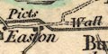
Picts Wall |
|
|
|
||
|
antiquities
earthworks |
An indeterminate symbol east of Mulcaster [Muncaster] is
labelled:-
Remains of the City of Barnsea |
|
|
|
||
| monuments |
An ?obelisk is drawn north of Burgh on the Sands,
labelled:-
Edward 1st. Monument |
|
|
|
||
|
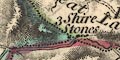
antiquities
stones stone circles |
East of Keswick is a label:-
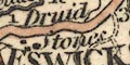
Druid Stones perhaps marked by a few blocks. This is Castlerigg Stone Circle. Three blocks, one in each county, at Wry Nose, are labelled:- 3 Shire Stones |
|
|
|
||
|
mines
coal mines |
A group of blocks east of Talkin is labelled:-
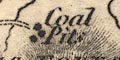
Coal Pitts |
|
Lakes Guides menu.