 Brookes 1773 map

|

|
|

|
back to object record | |
| MAP FEATURES | ||
|
These notes mostly ignore the parts of the map away from
Westmorland and Cumberland etc.
|
||
|
|
||
| title |
Printed in upper right in a baroque title cartouche:-
A New MAP of ENGLAND and WALES Divided into COUNTIES Drawn from the best Authorities. |
|
|
|
||
|
orientation
compass rose up is N |
Printed by the title cartouche, upper right, is a compass
rose; circle, star points for cardinal directions, lines for
half cardinal directions, North marked by a fleur de lys,
East marked by a cross. The map is printed with North at the
top of the sheet.
|
|
|
|
||
|
scale line
scale |
Printed lower right is a scale line:-
British Miles 69 to a Degree The 90 miles = 39.2 mm gives a scale 1 to 3694922 assuming a statute mile. The map scale is about:- 1 to 3700000 60 miles to 1 inch |
|
|
|
||
|
sea area
sea plain |
The sea area is plain, the area off Cumberland
labelled:-
IRISH SEA |
|
|
|
||
|
coast line
coast shaded headlands |
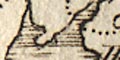
The coast line is emphasised by shading. A headland is labelled:- St. Bees Hd. |
|
|
|
||
| rivers |
Rivers are drawn by wiggly line tapering upstream. At this scale only the larger rivers are shown; most are not labelled, but see:- Duddon R Irt R. where space in the sea allows labelling. The:- Solway Firth is labelled. |
|
|
|
||
| lakes |
A few lakes are shown by inaccurate outline, shaded, not labelled. They can be recognised as:- Windermere Coniston Water Ullswater |
|
|
|
||
|
relief
hillocks |
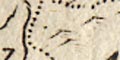
A few small hillocks suggest relief. A couple in the middle of Cumbria,a couple south of Brampton, a scatter down the Pennines. To the north the:- Cheviot Hills are labelled. |
|
|
|
||
| forests |
No woodland is indicated, but there is a label for:-
Lune For |
|
|
|
||
| county |
County boundaries are a dotted line. The county areas are labelled, eg:- CUMBERLAND WESTMORELAND |
|
|
|
||
| settlements |
Settlements are positioned by a circle, with added
elements, differentiated by style of labelling.
|
|
|
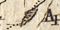
cities
towns |
circle, cross; labelled in upright lowercase text,
eg:-
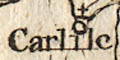
Carlile Appleby |
|
|
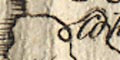
towns
villages |
circle; labelled in italic lowercase text, eg:-
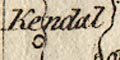
Kendal Brough Irton |
|
|
|
||
| miscellaneous | ||
|
|
||
|
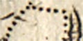
antiquities
roman sites roman wall |
Hadrian's Wall is sketched by a double line, solid
dotted, from Carlisle eastward, labelled:-
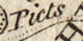
Picts Wall |
|
Lakes Guides menu.