 Bowen and Bowen 1767

|

|
|

|
back to object record | |
| MAP FEATURES | ||
|
|
||
|
title cartouche
floral cartouche map maker publisher |
Printed in a floral title cartouche, upper left:-
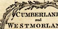
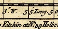
CUMBERLAND and WESTMORLAND, Divided into their respective WARDS. Exhibiting the City, Borough & Market Towns &c. with Historical Extracts relative to their Natural Produce, Trade & Manufactures. Describing also the Church Livings, with Improvements not Inserted in any other Set of Half Sheet County Maps Extant. By Eman: Bowen Geogr. & Thos. Bowen. Printed at the bottom:- Printed for Tho. Kitchin at No.59 Holborn Hill London. |
|
|
|
||
| descriptive text |
Printed in spare space around the two counties are panels
of descriptive text about the counties, towns, and some
rivers and lakes.
|
|
|
|
||
| table of symbols |
Printed lower left is an:-
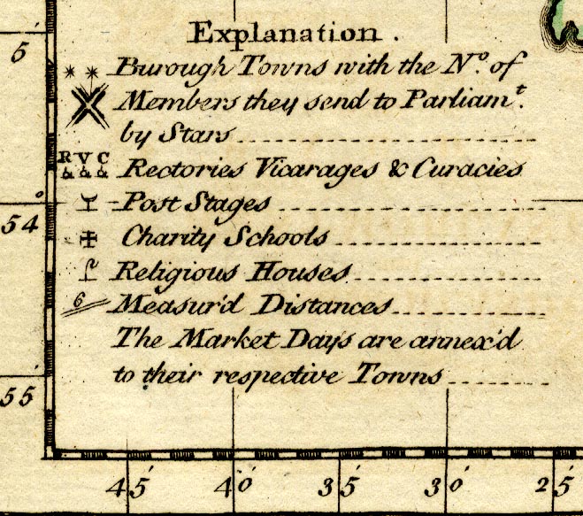
EXPLANATION [group of blocks on a street plan, two asterisks] Burough Towns with the No. of Members they send to Parliamt. by stars [circle and building, R; ditto V, ditto C] Rectories, Vicarages & Curacies [post with crescent symbol] Post Stages [cross paty] Charity School [crook] Religious Houses [number by double line] Measur'd Distances The Market Days are annex'd to their respective Towns. |
|
|
|
||
|
orientation
compass rose up is N |
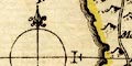
A minimal compass rose is drawn, align with the latitude and longitude grid, on the left; circle, N-S and E-W lines in the graticule, North marked by a spear point / fleur de lys, East marked by a cross. The map is printed with North at the top of the sheet. |
|
|
|
||
|
scale line
scale |
Printed upper left below the title is a scale of
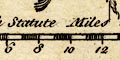
British Statute Miles chequered in miles, labelled 1,2 then at 2 mile intervals. The 16 miles = 44.9 mm gives a scale 1 to 573486. The map scale is about:- 1 to 570000 9 miles to 1 inch |
|
|
|
||
|
lat and long scales
lat and long grid |
Printed in the map borders are scales of latitude and longitude for a rectangular projection; chequered in minutes, labelled at 5 minute intervals. The bottom scale is labelled:- W Long from London From the scales the longitude, Kendal = 2d 50.8m which suggests a prime meridian a couple of degrees E of Greenwich. This is unlikely, the scales are perhaps wrong. A graticule is printed over the map at 10 minute intervals. |
|
|
|
||
|
sea area
sea plain |
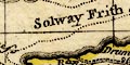
The sea area is plain, but filled with panels of
descriptive text and, of course, the latitude and longitude
grid lines. Some sea areas are labelled, eg:-
IRISH SEA Moricambe Solway Firth or Eden River Walney Island is missing, although the outline of Lancashire north of the sands is shown. |
|
|
|
||
|
coast line
coast form lines foreshore headlands |
The coast line is emphasized by form lines. Foreshore sands and shallows are outlined by a dotted line, and one sandbank is labelled:- Burr Sands A headland might be noticed, as:- St. Bees Head |
|
|
|
||
|
rivers
bridges |
Rivers are drawn by wiggly double line tapering to a
wiggly single line tapering upstream. Some rivers are
labelled, eg:-
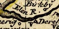
Elen R. Blenkeybeck R. Irt R. Bridges are implied where a road crosses and interrupts a stream. A few bridges are labelled, eg:- 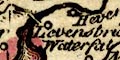
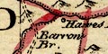
Levens bridge which is not part of the road network; and:- Emon Bri[ ] A waterfall might be noticed, as:- Waterfall below? Levens Bridge. |
|
|
|
||
| lakes |
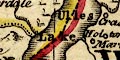
Lakes are drawn in outline, the shore shaded. Some lakes are labelled:- Broad Water [Ennerdale Water] Broad Water [Hawes Water] Coniston Mere Haws Water [perhaps Hayes Water] Ulles Lake Winander Mere Other lakes might be recognized, with some uncertainty, eg:- Bassenthwaite Lake Brothers Water (?) Burnmoor Tarn (?) Crummock Water (?) Derwent Water Devoke Water (?) Easedale Tarn (?) Grasmere Kentmere Tarn (?) Lowes Water (?) Rydal Water Wast Water |
|
|
|
||
|
relief
hillocks |
Relief is indicated by little hillocks shaded to the
east. These are fitted between place labels on the crowded
map; concentrations of hills occur where there are few
places, hardly a planned depiction of the shape of the
counties, though there are fewer places where there are more
hills. A few hills are labelled, eg:-
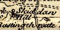
Skiddaw hill Kelloplaw Hard Knot Hill Fournes Fells And a valley might be labelled, eg:- Ennerdale |
|
|
|
||
|
trees
forests |
Some forest areas are marked by tree symbols and
labelled, eg:-
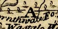
Thornthwaite Forest Copland Forest There are a few trees elsewhere, for example around Lambrigg, and in parks. |
|
|
|
||
| parks |
Parks are drawn by an outline with fence palings. A park
might be labelled, or names by its great house, eg:-
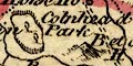
Colnhead Park Hartsop Hall |
|
|
|
||
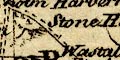
| county |
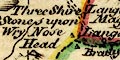
County boundaries are a dashed line, carried alongside a boundary feature, tinted on the inside for each county; Cumberland yellow, Westmorland pink, Lancashire green, Yorkshire blue-green, Durham green, Northumberland blue-green, Scotland pink. The county areas and adjacent counties are labelled, eg:- WESTMORELAND Near the meet of Westmorland with Lancashire and Yorkshire is labelled:- The County Stone Three stones are drawn, one in each county, Westmorland, Cumberland, Lancashire, labelled:- Three Shire Stones upon Wry Nose Head Very little is drawn outwith the two counties. |
|
|
|
||
| wards |
Ward boundaries are a fine dotted line, tinted with county's colour (beware: the tinting is incomplete). The ward areas are labelled. In Westmorland:- WEST WARD EAST WARD LONSDALE WARD KENDAL WARD In Cumberland:- CUMBERLAND WARD NORTH WARD SOUTH ALLERDALE WARD LEATH WARD ESKDALE WARD |
|
|
|
||
|
settlements
electoral data market days town walls |
Settlements are marked by a circle, perhaps with added
elements, or by groups of block on a minimal street plan,
differentiated by style of labelling.
|
|
| cities |
groups of blocks which make a poor street plan, within a
town wall; labelled in upright block caps:-
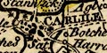
CARLILE / [two asterisks, cross paty] Sat. The city returns two members to Parliament; has a charity school; market day Saturday. I cannot find a post and crescent for a post stage. |
|
|
towns
market days |
group of blocks on a street plan, perhaps added elements;
labelled in upright lowercase text, eg:-
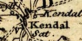
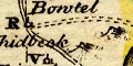
Kendal / V Sat. with a vicarage; market day Saturday. Cockermouth / Mon. a cha. [two asterisks] market day Monday; a chapelry; returns two members to Parliament. Cockermouth was a chapelry of Bridgham a little to the west, which has a vicarage. It would seem likely that these places were post stages, but I cannot see the post and crescent symbol 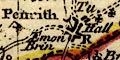
Penrith / Tu. R [2 crosses paty, post+crescent] market day Tuesday; a rectory; 2 charity schools; a post stage. Notice that Appleby, the de jure county town, is labelled in italic block caps. |
|
| villages |
circle, building? letter; labelled in italic lowercase
text, eg:-
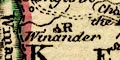
Winander / R Morland / V Beetham / V with a vicarage; Stapleton / R with a rectory; Seaton with neither. |
|
|
hamlets
houses |
circle; labelled in italic lowercase text, eg;-
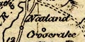
Natland Crosthwaite Grarig Hall Tebay [cross paty] The last with a charity school. |
|
| castles |
circle, with a flag; labelled in italic lowercase text,
eg;-
Kendal Castle Pendragon Castle lacks the flag. |
|
|
|
||
|
roads
road distances sands roads |
Roads are drawn by a double line, solid or dotted which might indicate fenced and unfenced, or the quality of the road or track. Distances between ?towns are marked by a number beside the road segment, for example near Hucks Bridge between Kendal and Penrith is:- 26 Between Ambleside and Keswick, north of Grasmere:- 16.2 
The sands road across Leven and lverton Sands is shown. |
|
|
|
||
| miscellaneous | ||
|
|
||
|
mines
black lead mines copper mines lead mines |
Stretching down the side of Derwent Water is a three part
label:-
Royal mines / Black Lead / Watendlath Mines The first refer to the headquarters of the Company of Mines Royal in Keswick, and on Derwent Island. The second to the black lead mine in Seathwaite. South of Milburn Forest is a group of circles labelled:- Lead Mines |
|
|
|
||
| peat mosses |
To the west of Penrith is a:-
peat moss Also notice:- The Moss north of Edenhall, and:- Sollome Moss [Solway Moss] |
|
|
|
||
|
wells
springs |
At the south of Ullswater is a circle labelled:-
St. Patrick's Well |
|
|
|
||
| stones |
Labelled near Tebay is:-
Bradrith Stone On the county boundary north of Grasmere is:- Dunmail Raise Stones and remember the Three Shire Stones, and The County Stone. |
|
|
|
||
| crosses |
On the border east of Kirkby Stephen is a cross
labelled:-
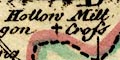
Hollow Mill Cross |
|
|
|
||
|
antiquities
roman sites roman wall |
A crenellated line from Boulness ie Bowness on Solway,
through Carlile, then north and east is labelled:-
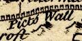
Picts wall demolish'd |
|
|
|
||
|
antiquities
stone circles |
At the road junction south of Shap are some stones
labelled:-
Stone Heap |
|
Lakes Guides menu.