 Blome 1673

|

|
|

|
back to object record | |
| MAP FEATURES | ||
|
|
||
|
title cartouche
scroll cartouche map maker dedication coat of arms |
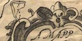
Printed in a scroll cartouche, lower right:- A MAPP OF YE COUNTYE OF WESTMORLAND DESCRIBED BY RIC: BLOME BY HIS MATY COMAND The map has a dedication to and the coat of arms of Sir John Lowther. 
Printed in a drape cartouche, upper left is the coat of arms of the Lowther Family:- or six annulets sable, 3,2,1 and dedication:- To The Honeble Sr. John Lowther Seinour of Lowther Hall Bart, This Mapp is Humbly Dedicated by Ric: Blome. |
|
|
|
||
|
orientation
labelled borders up is N |
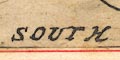
The map has labels in the four borders in English:- NORH (sic) / EAST / SOUTH / WEST |
|
|
|
||
|
scale line
scale |
Printed lower left is:-
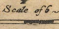
A Scale of 6 Miles chequered in miles, the marks not labelled. The 6 miles = 49.0 mm gives a scale 1 to 197063 wrongly assuming a statute mile. The map scale is about:- 1 to 200000 3 miles to 1 inch |
|
|
|
||
|
sea area
sea plain |
The small sea in river estuaries, is plain.
|
|
|
|
||
|
coast line
coast shaded foreshore |
The coast line of the river estuaries is shaded for emphasis. Confusingly, at first sight, the river channels between foreshore shallows, have another set of shading. |
|
|
|
||
|
rivers
bridges |
Rivers are drawn by a wiggly double line tapering to a single line upstream. The broader parts might have form lines. Some rivers are labelled, eg:- Can flu [Kent] Ermot flu [Eamont] Trout Beck It is not clear what flu stands for. It is easy to assume flumen or fluvius but notice that lake names might use the same abbreviation. Some lakes have been described as looking like large rivers, so the same word could be meant. But flud, ie flood, is a reasonable word for a lake, and could apply to a river. The engraving of river confluences, like much of the map, leaves much to be desired. The map has no roads, but a couple of bridges are marked by a double line, for the road, crossing and interrupting a stream, as at:- 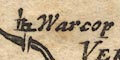
Warcop, and less neatly, but labelled, at:- New Bridge [Newby Bridge] There are a few other bridges labelled but not marked, eg:- Levens Bridge |
|
|
|
||
| lakes |
Lakes are drawn by an outline, the shore shaded, or
perhaps the lake filled with shading. Some lakes are
labelled, eg:-
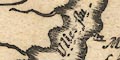
Ulles flu Wynandermere flu Others might be recognised, eg:- Brothers Water Coniston Water Easedale Tarn (?) Esthwaite Water Grasmere Rydal Water |
|
|
|
||
|
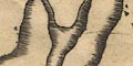
relief
hillocks |
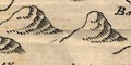
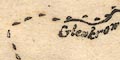
Relief is suggested by knobbly hillocks shaded to the east. The hills are clustered in the western part of the county, and on the north east boundary, but they are positioned elsewhere as well. A few hills are labelled, eg:- Helvillon hill Morton Pike Huseat Morvel hill Knothill [Farleton Knott] A line of hillocks makes Mallerstang Edge. |
|
|
|
||
|
woods
trees forests |
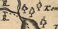
Tree symbols indicate some woodlands. These are mostly in parks, but also notice:- 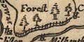
Whinfeld Forest Mallerstang Forest the latter in a park, and woods around Ambleside etc. |
|
|
|
||
| parks |
Parks are drawn by an outline with fence palings. Some
parks are labelled, or named by a house, eg:-
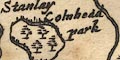
Colnhedd park [by Staveley] Wharton Hall in which the h was missed by the engraver and placed above. |
|
|
|
||
|
county
swash lettering |
The county boundary is a dashed line, continued alongside an other boundary feature Adjacent counties are labelled, eg:- PART OF CUMBERLAND The label for Yorkshire has extended ascenders and descenders, the engraver's attempt at swash lettering. A little is drawn outwith the county for the sake of continuity. |
|
|
|
||
| settlements |
Settlements are marked by a circle with added elements,
but are not reliably differentiated by style of labelling.
The size of labelling varies, but this seems to depend on
how much space is available rather than the importance of
the place.
|
|
| towns |
circle, buildings, tower; labelled in italic lowercase
text, eg:-
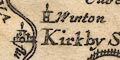
Kirkby Steven Kendall |
|
|
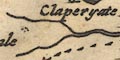
villages
hamlets |
circle, tower; labelled in italic lowercase text,
eg:-
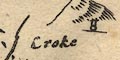
Croke [Crook] Barnside [Burneside] Ambleside |
|
|
|
||
| miscellaneous | ||
|
|
||
|
antiquities
tribal areas |
The county is labelled:-
THE BRIGANTES |
|
|
|
||
|
antiquities
roman sites roman towns |
Roman placenames are given alongside some modern names,
eg:-
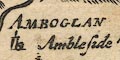
AMBOGLAN [Ambleside] CALLAGUM [Temple Sowerby] ABBALLADA [Branton = Brampton] VERTERAE [Warcop/Great Musgrave] |
|
|
|
||
| stones |
Two stone symbols are labelled:-
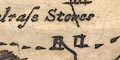
Dunbalrase stones |
|
|
|
||
| beacons |
On a hillock north of Penrith is a tower symbol, but not
labelled. This is Penrith Beacon.
On a hillock north east of Orton there is a ?post with rungs, labelled:- 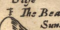
The Beacon |
|
|
|
||
| crosses |
On a hillock on the east boundary is a cross
labelled:-
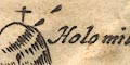
Holomill Crosse |
|
Lakes Guides menu.