 Bell 1833

|

|
|

|
back to object record | |
| MAP FEATURES | ||
|
Most notes are made from the Westmorland map.
|
||
|
|
||
|
title
publisher |
Printed upper left:-
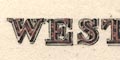
WESTMORELAND Printed at the bottom:- Published by Archd. Fullarton & Co. |
|
|
|
||
| vignettes |
Printed lower right is a vignette scene of:-
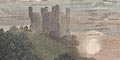
BROUGH CASTLE in a romantic setting, with the River Eden, bridge, castle, sunset, etc. The companion map of Cumberland has a vignette scene of Carlisle in which can be seen the Citadel, Carlisle Cathedral, Carlisle Castle, Eden Bridge, River Eden, etc. |
|
|
|
||
|
orientation
compass rose up is N |
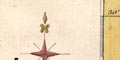
Printed upper right is a compass rose; no circle, star points for the cardinal directions, lines for half cardinal directions, North marked by a spear point. The map is printed with North at the top of the sheet. The Cumberland map is also printed with North at the top, but, suiting their shapes, Westmorland would have been the right way up as the atlas pages were turned, Cumberland would have been on its side. |
|
|
|
||
|
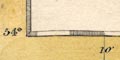
scale line
scale |
Printed lower left is a scale line of:-
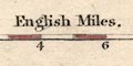
English Miles. chequered in miles, labelled at 2 mile intervals. the 10 miles = 47.1 mm, gives a map scale 1 to 341687 assuming a statute mile. the map scale is about:- 1 to 340000 5.5 miles to 1 inch Fitted on the same size page in an atlas, the Cumberland map scale is about 8 miles to 1 inch. |
|
|
|
||
|
lat and long
lat and long scales |
printed in the map borders are scale of latitude and longitude for a slightly slanted rectangular projection; chequered in 2 minute intervals, labelled at 10 minute intervals. The bottom scale is labelled:- Longitude West from Greenwich The map includes from 2d 4m to 3d 14m W, from 54d 0m to 54d 32m N; the whole of Westmorland. |
|
|
|
||
|
coast line
coast shaded |
A tiny bit of coast line is shown in the Kent Estuary, the area visible shaded and tinted blue. |
|
|
|
||
|
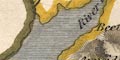
rivers
bridges ferries |
Rivers are drawn by wiggly line tapering upstream. Some rivers are labelled, eg:- River Ken R. Leven Crowdundle Beck Lune R. Bridges are implied where a road crosses and interrupts a stream. None? are labelled. A dotted line across lake Windermere is labelled:- 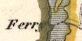
Ferry |
|
|
|
||
| lakes |
Lakes are drawn in outline, shaded, and the large lakes
tinted blue. Some are labelled:-
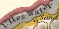
Ulles Water Winander mere Grasmere L. Elter Water Hawes [Wt] Reservoir [Killington] Others might be recognised, eg:- Rydal Water Brothers Water (?) Hayes Water (?) |
|
|
|
||
|
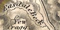
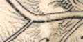
relief
hill hachuring |
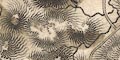
Relief is indicated by hill hachuring, tinted pale brown. There is quite a good impression of hilly areas and valleys. Some hills are labelled, eg:- Helvellin Shap Fells Whitbarrow Scar Some valleys are labelled, eg:- Graysdale [Grisedale] Patterdale |
|
|
|
||
| beacons |
Although not well located, at least one beacon is
noticed:-
Barbon Beacon Probably naming the hill not the beacon. |
|
|
|
||
| forests |
Wood land is not indicated, but some forest areas are
labelled, eg:-
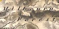
Milburn Forest |
|
|
|
||
| parks |
Parks are drawn in outline, the interior pecked? and
tinted green, possible labelled, eg:-
Levens Pa. |
|
|
|
||
| county |
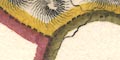
The county boundary is a dashed line, sometimes continued alongside another feature - as by the River Winster, elsewhere not shown - as in Ullswater. The boundary between adjacent counties is indicated. County areas have a tint along their boundary; Westmorland yellow, Lancashire north of the sands, green, the other part of Lancashire red, Cumberland red, Durham orange? Yorkshire blue. Adjacent counties are labelled, eg:- CUMBERLAND Very little is shown outwith the county, except Penrith and Sedbergh for the continuity of roads. Various features are noticed on the county boundary, in particular:- 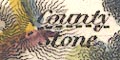
County Stone [Yorkshire, Lancashire, Westmorland] Lady Pillar [SE border] |
|
|
|
||
|
wards
table of wards |
Wards, comparable to hundreds, are divided by a fine dotted boundary line, the areas labelled by number which keys to a table printed lower left:- REFERENCE to the WARDS 1 East ward 2 West ward 3 Kendal 4 Lonsdale |
|
|
|
||
|
settlements
distances from London |
Settlements are marked by blocks, differentiated by style
of labelling.
|
|
| cities |
The Cumberland map in the series labels:-
CARLISLE / 301 in upright block caps. |
|
| towns |
blocks, tinted red; labelled in upright lowercase text,
eg:-
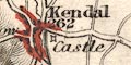
Kendal / 262 Ambleside / 278 except:- APPLEBY / 270 in italic block caps, as the de jure county town. Printed lower left is:- The Figures prefixed to the Towns denote the distance from London. |
|
|
villages
hamlets |
block or blocks, perhaps a cross for a church, perhaps
only the cross; labelled in italic lowercase text, eg:-
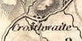
Crosthwaite Askham 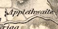
Applethwaite Clifton This style of lettering is used generally for map features. |
|
|
houses
castles |
A house, large or small, might be marked by a block, and
labelled, eg:-
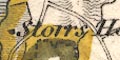
Storrs Hall Gill Stone [Kilnstones, Longsleddale] A castle is marked with a square with projecting lines at each corner, labelled, eg:- 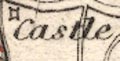
Castle [at Kendal] |
|
|
|
||
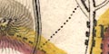
| roads |
A network of roads is drawn by double line: broad with light bold lines, perhaps indicating turnpikes; narrow for lesser routes. The destination of some routes is labelled at the county boundary, eg:- to Barnard Castle from Ulverstone |
|
|
|
||
| canals |
A canal is drawn by a triple line, light bold light. |
|
| Lancaster Canal |
from the south, to Kendal.
|
|
|
|
||
| miscellaneous | ||
|
|
||
| peat mosses |
A label on the west bank of the Kent Estuary
indicates:-
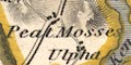
Peat Mosses |
|
|
|
||
| stones |
At the meet of Yorkshire, Lancashire, and Westmorland
is:-
County Stone |
|
Lakes Guides menu.