 Badeslade 1742

|

|
|

|
back to object record | |
| MAP FEATURES | ||
|
At least two versions of the map were made, the earlier
version with far fewer places, 1741. These notes are from a
later version example, 1742.
|
||
|
|
||
|
title
map maker engraver publisher |
Printed at the top is:-
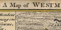
A Map of WESTMORLAND North from London Printed bottom left, centre, and right:- T. Badeslade delin. / Publish'd by the proprietor W H Toms Sept. 29. 1742 / W. H. Toms Sculpt |
|
|
|
||
|
orientation
compass rose up is N |
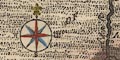
Printed upper left is a compass rose; circle, star points for cardinal and half cardinal directions, North marked by a fleur de lys, East marked by a cross, E, S and W labelled by letter. The map is printed with North at the top of the sheet. |
|
|
|
||
|
scale line
scale |
Printed lower right is a scale of:-
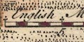
English Miles chequered in miles, labelled at 5 mile intervals. The 10 miles = 25.5 mm gives a map scale 1 to 631115 assuming a statute mile. The map scale is about:- 1 to 630000 10 miles to 1 inch |
|
|
|
||
|
sea area
sea plain |
The small sea area is plain.
|
|
|
|
||
|
coast line
coast form lines |
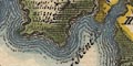
The coast line is emphasised by form lines, tinted blue on the map studied. |
|
|
|
||
|
rivers
bridges |
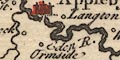
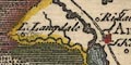
Rivers are drawn by a double line with form lines tapering to a single wiggly line tapering upstream. Some rivers are labelled, eg:- Can or Kent R. Burrow R. Loder R. [Lowther] 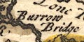
Bridges are suggested by a road crossing and interrupting a stream. Other bridges are indicated by a gap in a stream, as at Kirby Lonsdale and Appleby. Or, difficult to see and uncertain, by a short segment of road engraved across a river, as labelled at:- Burrow Bridge |
|
|
|
||
| lakes |
Lakes are drawn in outline with form lines, some tinted blue on the map studied. They are not labelled. With varying certainty it is possible to recognise:- Windermere Rydal Water Kentmere Haweswater Brothers Water ? Hayes Water ? ??? Ullswater is missing. In adjacent Lancashire is:- Coniston Water |
|
|
|
||
|
relief
hillocks |
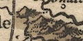
A small group of hillocks is drawn north of the Burrow River, ie the Shap Fells?, and a hillock or two at Whinfield. There are hillocks down the border with Yorkshire in the east. And that is all. On the map studied the hillocks are tinted brown. Rumary fell is labelled north of Brough. |
|
|
|
||
| woods |
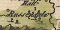
There are a few tree symbols about Russendale south of Kirby Steven, the area around tinted green on the map studied. |
|
|
|
||
| county |
County boundaries are a dotted line, emphasised by shading. The adjacent county areas are pecked, which gives a heavy feel to the map overall. Adjacent county areas are labelled, eg:- PART OF CUMBERLAND PART OF LANCA SHIRE The map studied has a tint along the inner side of each county border. Westmorland is yellow; Lancashire green, Cumberland pink, Durham a blue green, Yorkshire pink the ridings not distinguished though their boundary is marked. A few features are drawn outwith the county, Penrith, Carlisle, Lancaster, for instance, and some rivers. |
|
|
|
||
|
settlements
distances from London electoral data |
Settlements are marked by a circle, with added elements,
differentiated by style of labelling.
|
|
| towns |
circle, buildings and towers; labelled in upright
lowercase text, eg:-
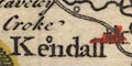
Kendall / 203 m Appleby Kirby Lonsdale The figure by Kendall is the distance from London. Appleby has two asterisks attached, indicating that it returns two members to Parliament. On the map studied the towns are tinted red. |
|
| villages |
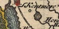
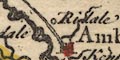
circle; labelled in italic lowercase text, eg:-
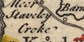
Staveley Ridale Pooley This style of labelling is used for other features on the map. |
|
|
|
||
| towns |
The following places are marked and labelled as
towns:-
|
|
| Westmorland towns |
Ambleside [circle, buildings, tower]
Appleby [circle, buildings, towers, 2 asterisks] Brough [circle, tower] Burton [circle, buildings, tower] Kendall [circle, buildings, tower] Kirby Lonsdale [circle, buildings, tower] Kirby Steven [circle, buildings, tower] Orton [circle, tower] Shap [circle, tower] |
|
|
|
||
| roads |
Two roads are drawn by double line; the two Ogilby routes. From the south through Lancaster, Lancashire; then Burton, Frandon, Grove Church, Kendall, by two Horse houses on the way to Shap, Westmorland, and over the Loder and Eymot to; Penrith, Cumberland. From Kendall, by Staveley, then Winander Mere to Ambleside, Westmorland; and then to the north west towards Keswick, Cumberland. |
|
|
|
||
| miscellaneous | ||
|
|
||
| horse houses |
Marked by the road across the Shap Fells is:-
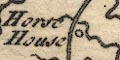
which could be marking the provision of horses on this lonely road. |
|
| Descriptive Text | ||
|
In a panel at the left of the map there is descriptive text
about the county:-
|
||
|
Westmorland sends 4 members to Parliament, containing one
Borough, 8 Market Towns, and 26 large Parishes.
|
||
|
Appleby the County Town, sends 2 Members, Market Saturday,
Fair May 30.
|
||
|
Ambleside Market Wednesday.
|
||
|
Brough Market Wednesday.
|
||
|
Burton Tuesd. Fairs March 25. and Whitsun-monday.
|
||
|
Kirby in Kendale is the largest Town in the County, Market
Saturday, Fairs Monday before Lady-day, and Trinity Monday.
|
||
|
Kirby Lonsdale Market Thursd:
|
||
|
Kirby Steven Market Friday, Fair Whitsun-monday.
|
||
|
Orton Market Wednesday.
|
||
|
Shap
|
||
|
The W. side of this County is divided from Cumberland by
Winander Meer, & the River Winster. The N.W. Boundary is the
River Eimot, which receives the Loder, and at last unites
with the Eden. The S. part of the County is divided into 2
by the Can or Ken, which gives name to Kendale & the Lone or
Lune after having received the River Burrow is the Boundary
to Yorkshire, then passes by Kirby Lonsdale into Lancashire.
The River Eden rises in the E. part of the County, receives
first the little River Belo, afterwards Blenkern, & at the
N. point unites with Eimot, and flows into Cumberland.
|
||
Lakes Guides menu.