 Bacon c1890s

|

|
|

|
back to object record | |
| MAP FEATURES | ||
|
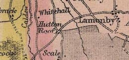
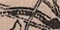
A number of G W Bacon's maps were produced by lithographic
transfer. Signs of this process can be seen in this map.
Firstly there is a poor join of two parts of the image
running across the map about 42m North:-
|
||
|
||
|
Photographic processes often produce images with stretch or
shrink problems at the edges, caused by barrel or pincushion
distortion in the lens. These problems make it hard to paste
two images together (and are one of the reasons we prefer
flatbed scanning to make map images which are metrically
reliable).
|
||
|
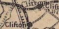
More crudeness can be seen where the title has been pasted
over map areas at the bottom right of the sheet:-
|
||
|
||
|
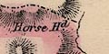
In at least one place a placename is partly cut off.
|
||
|
|
||
|
title
map maker descriptive text |
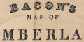
Printed lower right using three decorative fonts:- BACON'S MAP OF CUMBERLAND Printed bottom centre:- LONDON. G. W. BACON & CO. 127, STRAND. Printed on a label on the card cover, black on yellow:- BACON'S NEW POCKET MAP OF CUMBERLAND FROM THE ORDNANCE SURVEY. WITH THE NAME OF EVERY RAILWAY STATION. In cloth case 6d. On cloth 1s. LONDON G. W. BACON & CO., 127, STRAND, AND ALL BOOKSELLERS. Printed below the title is:- Cumberland contains 1001273 Statute Acres 1565 Square Miles ... |
|
|
|
||
|
orientation
up is N |
The map is printed with North at the top of the sheet.
|
|
|
|
||
|
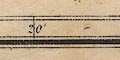
scale line
scale |
Printed lower right beneath the title is a scale of:-
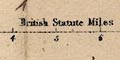
BRITISH STATUTE MILES marked and labelled at miles. The 10 miles = 75.4 mm gives a scale 1 to 213441 on the reasonable assumption that a statute mile is used. The map scale is about:- 1 to 210000 ? 3.5 miles to 1 inch |
|
|
|
||
| lat and long scales |
Printed in the map borders are scale of latitude and longitude for a trapezoidal projection; marked and labelled at 10 minute intervals. The map includes from 2d 14m to 3d 33m W, from 54d 18m to 55d 10m N; allowing bits over the map edges this is most of Cumberland. An inset map is needed for the Millom peninsula, labelled:- CONTINUATION OF CUMBERLAND on same scale. |
|
|
|
||
|
sea area
sea plain sandbanks |
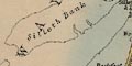
The sea area is plain. A few sea areas are labelled, eg:- SOLWAY FIRTH Salton Bay Sandbanks might be shown by a dotted outline, perhaps labelled, eg:- Silloth Bank Middle Bank |
|
|
|
||
|
coast line
coast tinted foreshore headlands harbours lighthouses |
The coast line is emphasised by a blue tint in the offing. Foreshore shallows are delimited by a dotted line, and sands in an estuary might be labelled, eg- Duddon Sands Some headlands are labelled, eg:- St. Bees Head Tarn Pt. Dubmill Point Some harbours are noticed, eg:- Port Carlisle Silloth Port & Dock Whitehaven harbour is marked by two moles out from the shore. |
|
|
|
||
|
rivers
bridges waterfalls |
Rivers are drawn by a wiggly line tapering upstream. Some rivers are labelled, in a variety of styles, eg:- R. Bleng Eden River Gelt Riv. Esk R. Trout Beck Croglin Water Ease Gill Bridges are implied where a road crosses and interrupts a stream. A few bridges are labelled, perhaps by settlement names, eg:- 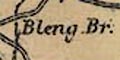
Esk Bridge Stockley Br. Ouse Br. Pooley Bridge Waterfalls might be marked by two or three lines across a stream, and labelled, eg:- Sour Milk Force Birker Force Scale Force |
|
|
|
||
| lakes |
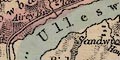
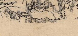
Lakes are drawn in outline. The larger lakes are tinted blue, which might be discoloured by the overall county area tint, compare Ullswater and Derwent Water for instance. Or the lake might just be shaded, or left plain. Many lakes are labelled:- Angle Tarn Bassenthwaite Blea Tarn [above Watendlath] Blea Tarn [Langdales] Bleaberry Tarn [by Buttermere] Bleaberry Tarn [near Boot] Brothers Water Burnmoor Tarn Buttermere Codale Tarn Crummock Water Dale Head Tarn Derwent Water Devoke Water Eel Tarn Ennerdale Wr. Gates Wr. Greencastle Tarn Greendale Tarn Gt. Rundle Tarn Harrow Tarn Hawes Water Hayes Water Keppel Cove Tarn Lit. Rundle Tarn Lit. Tarn [by Orthwaite Hall] Lowes Water Martin Tarn Over Water Red Tarn Scales Tarn Seathwaite Tarn Sprinkling Tarn Stickle Tarn Stoney Tarn Sty Hd. Tarn Talkin Tarn Tarn Wadling Tarn [at Watendlath] Thirlmere or Leathes Water Tindale Tarn Ulleswater Wast Water Whins Tarn Winter Tarn Other lakes might be recognised, eg:- Grisedale Tarn Low Birker Tarn Low Water [?] Mockerkin Tarn |
|
|
|
||
|
relief
hill hachuring spot heights |
Relief is indicated by hill hachuring. Some hills are labelled, some have spot heights, eg:- Cross Fell / 2901 Ft. Mell Fell High Pike / 2911 Ft. Hard Knot |
|
|
|
||
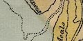
| forests |
Woodland is not indicated. Some forest areas are
labelled, which might, of course, not be woodland.
Examples:-
King's Forest of Geltsdale Copeland Forest Inglewood Forest |
|
|
|
||
| parks |
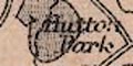
Parks might be drawn in outline, the interior dotted. The park might be labelled, or named by its great house, eg:- Greystoke Park Gowbarrow Park [not drawn, just labelled] |
|
|
|
||
|
county
divisions electoral data |
The county boundary is a dot dash line; this and other boundaries might or might not be continued along another feature which marks the boundary. 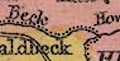
The two electoral divisions are separated by a fine dotted line. Each division area is tinted palely, with a stronger tint along the inside of its boundary; Western Division yellow, Eastern Division pink. The division areas are labelled, eg:- WESTERN DIVISION 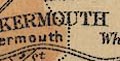
Borough areas are bounded by a fine dotted line and tinted brown. Basic electoral data is printed below the title, lower right:- Cumberland ... returns 4 Members to Parliament for the County 2 for each Division 2 for Carlisle & 1 each for Cockermouth & Whitehaven. There seems to be some attempt to label features on the county boundary, noticeable on the east. Some railways and roads are drawn outwith the county for continuity. In the adjacent areas of Lancashire and Westmorland the topographical mapping is continued, only obscured by the paste up of the inset map and title area. |
|
|
|
||
| settlements |
Settlements are marked by blocks and group of blocks,
differentiated by style of labelling.
|
|
|
cities
towns, borough |
group of blocks; labelled in upright block caps, eg:-
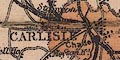
CARLISLE COCKERMOUTH |
|
| towns |
group of blocks; labelled in italic block caps, eg:-
PENRITH KESWICK |
|
| villages |
blocks, perhaps a cross for a church; labelled in upright
lowercase text, eg:-
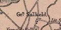
Gt. Salkeld Patterdale Wastdale [Nether Wasdale] |
|
| hamlets |
a block or blocks; labelled in italic lowercase text,
eg:-
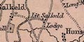
Lit. Salkeld Wasdale Head Glassonby |
|
|
|
||
| roads |
A network of roads is drawn by double lines. More important roads are a little wider and may have one line bolder. Some lines are dotted, which might suggest unfenced or just lower quality routes. |
|
|
|
||
| railways |
Railways are clearly drawn by a network of bold lines, solid black alternating with double line with cross ties. Some are labelled, eg:- Lancaster & Carlisle Carlisle & Newcastle Ry. Caledonian Railway Stations are marked by a black dot and are named, eg:- Plumpton Calthwaite Southwaite but see, printed below the title:- Note The official names of Railway Stations are all engraved in a special character thus Ludgate: except where indicated by the name of the town being in bold letters and identical with the name of the Station. Some stations get labelled even if the place is labelled the same, as at Shap. |
|
|
|
||
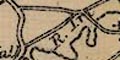
| canals |
Canals are drawn by a black line. If you look carefully you can see the canal from Carlisle to Port Carlisle. |
|
|
|
||
| miscellaneous | ||
|
|
||
| inns |
A few inns are labelled, outside of settlements, eg:-
Wheatsheaf [W of Bassenthwaite] Wool Pack [Eskdale] |
|
|
|
||
|
antiquities
stone circles |
A ring of dots marks a:-
Druidical Circle at Burnmoor and Castlerigg for example. Long Meg & her daughters is just labelled. |
|
|
|
||
|
antiquities
roman sites roman forts roman wall |
One or two places are labelled:-
Camp but more useful is:- Old Carlisle south of Wigton. Hadrian's Wall is marked by a line with fence palings, the style used on many maps for enclosed parks, labelled:- Picts Wall from Bowness on Solway, through Carlisle, and eastward. |
|
|
|
||
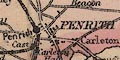
| beacons |
A beacon is labelled:-
Doffenside Beacon marked by a post with a ?cresset. Penrith Beacon is just labelled. |
|
|
|
||
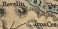
| ironworks |
On the ENE shoulder of Cross Fell is:-
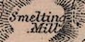
Smelting Mills and another a little further east. |
|
|
|
||
|
mines
lead mines |
On the south of Dufton Fell are:-
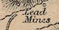
Lead Mines with others nearby. |
|
|
|
||
| race courses |
North of Penrith is a dotted oval labelled:-
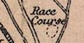
Race Course |
|
|
|
||
| monuments |
On the Solway shore is:-
King Edwards Monumt. |
|
|
|
||
| stones |
East of Ireby is:-
Thorney Stone and on the eastern border near Cold fell Pike is:- Blackbrock Stone |
|
Lakes Guides menu.