 Aikin 1790

|

|
|

|
back to object record | |
| MAP FEATURES | ||
|
|
||
| title |
Printed lower right:-
WESTMORELAND. in a fancy font. |
|
|
|
||
|
orientation
up is N |
The map is printed with North at the top of the
sheet.
|
|
|
|
||
| scale |
A rough estimate of the map scale from measuring the
positions of a few places is:-
1 to 540000, approx 8.5 miles to 1 inch, approx |
|
|
|
||
|
sea area
sea plain |
A tiny area of sea in the Kent Estuary is plain.
|
|
|
|
||
|
coast line
coast form lines |
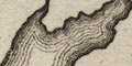
The coast line in the Kent Estuary is emphasised by form lines. |
|
|
|
||
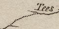
| rivers |
Rivers are drawn by wiggly line tapering upstream. The
major rivers are labelled, eg:-
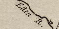
Eden R Ken R. Eymot R. [Eamont] and a few tributaries are shown. |
|
|
|
||
| lakes |
Larger lakes are drawn in outline with form lines. A lake
might be labelled:-
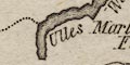
Ulles Water Winander Meer Grasmere and others can be recognised:- Haweswater Rydal Water Cow Green Reservoir [now] Belle Isle in Windermere can be recognised. |
|
|
|
||
| forests |
Woodland is not indicated, but:-
Martindale Forest is labelled. |
|
|
|
||
| county |
The county boundary is a dotted line, which is not continued along a boundary feature. Adjacent counties are not divided, but are labelled, eg:- CUMBERLAND YORK SHIRE |
|
|
|
||
| settlements |
The few settlements on this empty map are marked by a
circle, perhaps with added elements, differentiated by style
of lettering.
|
|
| towns |
circle; labelled in italic lowercase text, eg:-
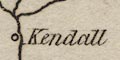
Kendall Orton but in upright lowercase text:- Appleby the de jure county town, whose circle has an added vestigial building or tower. |
|
Lakes Guides menu.